You are here: Home > Network List > CN - Canadian National Seismograph Network Stations List
> Station INK INUVIK, NT > Earthquake Result Viewer
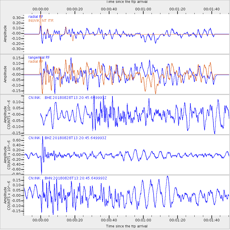
INK INUVIK, NT - Earthquake Result Viewer
*The percent match for this event was below the threshold and hence no stack was calculated.
| Earthquake location: |
Fiji Islands Region |
| Earthquake latitude/longitude: |
-18.0/-177.9 |
| Earthquake time(UTC): |
2018/08/28 (240) 13:09:10 GMT |
| Earthquake Depth: |
592 km |
| Earthquake Magnitude: |
5.7 Mww |
| Earthquake Catalog/Contributor: |
NEIC PDE/us |
|
| Network: |
CN Canadian National Seismograph Network |
| Station: |
INK INUVIK, NT |
| Lat/Lon: |
68.31 N/133.53 W |
| Elevation: |
44 m |
|
| Distance: |
91.9 deg |
| Az: |
15.092 deg |
| Baz: |
221.784 deg |
| Ray Param: |
$rayparam |
*The percent match for this event was below the threshold and hence was not used in the summary stack. |
|
| Radial Match: |
62.883236 % |
| Radial Bump: |
400 |
| Transverse Match: |
38.32712 % |
| Transverse Bump: |
400 |
| SOD ConfigId: |
13570011 |
| Insert Time: |
2019-05-01 00:38:33.193 +0000 |
| GWidth: |
2.5 |
| Max Bumps: |
400 |
| Tol: |
0.001 |
|
Signal To Noise
| Channel | StoN | STA | LTA |
| CN:INK: :BHZ:20180828T13:20:45.649993Z | 5.387572 | 2.925255E-7 | 5.429635E-8 |
| CN:INK: :BHN:20180828T13:20:45.649993Z | 1.198876 | 7.108852E-8 | 5.9295974E-8 |
| CN:INK: :BHE:20180828T13:20:45.649993Z | 1.4338855 | 6.6154044E-8 | 4.613621E-8 |
| Arrivals |
| Ps | |
| PpPs | |
| PsPs/PpSs | |


