You are here: Home > Network List > TA - USArray Transportable Network (new EarthScope stations) Stations List
> Station S18A Hurst Farm, Blanding, UT, USA > Earthquake Result Viewer
S18A Hurst Farm, Blanding, UT, USA - Earthquake Result Viewer
| Earthquake location: |
Southern Peru |
| Earthquake latitude/longitude: |
-16.0/-71.7 |
| Earthquake time(UTC): |
2008/07/08 (190) 09:13:07 GMT |
| Earthquake Depth: |
123 km |
| Earthquake Magnitude: |
5.8 MB, 6.2 MW, 6.2 MW |
| Earthquake Catalog/Contributor: |
WHDF/NEIC |
|
| Network: |
TA USArray Transportable Network (new EarthScope stations) |
| Station: |
S18A Hurst Farm, Blanding, UT, USA |
| Lat/Lon: |
37.69 N/109.99 W |
| Elevation: |
2351 m |
|
| Distance: |
64.4 deg |
| Az: |
326.996 deg |
| Baz: |
138.669 deg |
| Ray Param: |
0.05863073 |
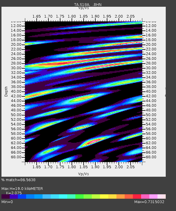
| Estimated Moho Depth: |
19.0 km |
| Estimated Crust Vp/Vs: |
2.08 |
| Assumed Crust Vp: |
6.476 km/s |
| Estimated Crust Vs: |
3.121 km/s |
| Estimated Crust Poisson's Ratio: |
0.35 |
|
| Radial Match: |
86.5638 % |
| Radial Bump: |
400 |
| Transverse Match: |
77.87929 % |
| Transverse Bump: |
400 |
| SOD ConfigId: |
2504 |
| Insert Time: |
2010-03-06 14:53:18.961 +0000 |
| GWidth: |
2.5 |
| Max Bumps: |
400 |
| Tol: |
0.001 |
|

Signal To Noise
| Channel | StoN | STA | LTA |
| TA:S18A: :BHN:20080708T09:22:59.449014Z | 8.569116 | 5.829766E-7 | 6.803229E-8 |
| TA:S18A: :BHE:20080708T09:22:59.449014Z | 2.5752764 | 2.6104723E-7 | 1.01366695E-7 |
| TA:S18A: :BHZ:20080708T09:22:59.449014Z | 2.7612367 | 1.7565849E-7 | 6.361588E-8 |
| Arrivals |
| Ps | 3.3 SECOND |
| PpPs | 8.7 SECOND |
| PsPs/PpSs | 12 SECOND |


