You are here: Home > Network List > TA - USArray Transportable Network (new EarthScope stations) Stations List
> Station S18A Hurst Farm, Blanding, UT, USA > Earthquake Result Viewer
S18A Hurst Farm, Blanding, UT, USA - Earthquake Result Viewer

| Earthquake location: |
Off East Coast Of Honshu, Japan |
| Earthquake latitude/longitude: |
37.6/142.2 |
| Earthquake time(UTC): |
2008/07/19 (201) 02:39:28 GMT |
| Earthquake Depth: |
22 km |
| Earthquake Magnitude: |
6.2 MB, 7.0 MS, 7.0 MW, 6.9 MW |
| Earthquake Catalog/Contributor: |
WHDF/NEIC |
|
| Network: |
TA USArray Transportable Network (new EarthScope stations) |
| Station: |
S18A Hurst Farm, Blanding, UT, USA |
| Lat/Lon: |
37.69 N/109.99 W |
| Elevation: |
2351 m |
|
| Distance: |
79.8 deg |
| Az: |
50.127 deg |
| Baz: |
309.746 deg |
| Ray Param: |
0.048680983 |
| Estimated Moho Depth: |
54.0 km |
| Estimated Crust Vp/Vs: |
2.04 |
| Assumed Crust Vp: |
6.476 km/s |
| Estimated Crust Vs: |
3.182 km/s |
| Estimated Crust Poisson's Ratio: |
0.34 |
|
| Radial Match: |
92.145744 % |
| Radial Bump: |
400 |
| Transverse Match: |
81.246994 % |
| Transverse Bump: |
400 |
| SOD ConfigId: |
2504 |
| Insert Time: |
2010-03-06 14:53:19.836 +0000 |
| GWidth: |
2.5 |
| Max Bumps: |
400 |
| Tol: |
0.001 |
|
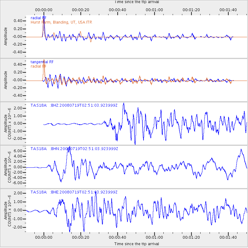
Signal To Noise
| Channel | StoN | STA | LTA |
| TA:S18A: :BHN:20080719T02:51:03.923999Z | 7.30993 | 5.957169E-7 | 8.1494214E-8 |
| TA:S18A: :BHE:20080719T02:51:03.923999Z | 1.8951793 | 1.4930059E-7 | 7.877914E-8 |
| TA:S18A: :BHZ:20080719T02:51:03.923999Z | 2.539788 | 1.6523585E-7 | 6.505891E-8 |
| Arrivals |
| Ps | 8.9 SECOND |
| PpPs | 25 SECOND |
| PsPs/PpSs | 34 SECOND |


