You are here: Home > Network List > TA - USArray Transportable Network (new EarthScope stations) Stations List
> Station D25K Kavik River, AK, USA > Earthquake Result Viewer
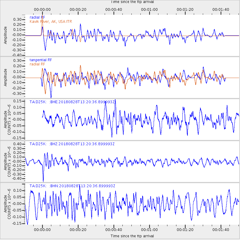
D25K Kavik River, AK, USA - Earthquake Result Viewer
*The percent match for this event was below the threshold and hence no stack was calculated.
| Earthquake location: |
Fiji Islands Region |
| Earthquake latitude/longitude: |
-18.0/-177.9 |
| Earthquake time(UTC): |
2018/08/28 (240) 13:09:10 GMT |
| Earthquake Depth: |
592 km |
| Earthquake Magnitude: |
5.7 Mww |
| Earthquake Catalog/Contributor: |
NEIC PDE/us |
|
| Network: |
TA USArray Transportable Network (new EarthScope stations) |
| Station: |
D25K Kavik River, AK, USA |
| Lat/Lon: |
69.32 N/146.38 W |
| Elevation: |
770 m |
|
| Distance: |
90.0 deg |
| Az: |
10.717 deg |
| Baz: |
209.878 deg |
| Ray Param: |
$rayparam |
*The percent match for this event was below the threshold and hence was not used in the summary stack. |
|
| Radial Match: |
56.365456 % |
| Radial Bump: |
400 |
| Transverse Match: |
59.43185 % |
| Transverse Bump: |
400 |
| SOD ConfigId: |
13570011 |
| Insert Time: |
2019-05-01 00:40:58.790 +0000 |
| GWidth: |
2.5 |
| Max Bumps: |
400 |
| Tol: |
0.001 |
|
Signal To Noise
| Channel | StoN | STA | LTA |
| TA:D25K: :BHZ:20180828T13:20:36.899993Z | 2.789989 | 1.5639125E-7 | 5.605444E-8 |
| TA:D25K: :BHN:20180828T13:20:36.899993Z | 0.7176548 | 4.4992024E-8 | 6.2693125E-8 |
| TA:D25K: :BHE:20180828T13:20:36.899993Z | 1.2902836 | 4.3221192E-8 | 3.3497436E-8 |
| Arrivals |
| Ps | |
| PpPs | |
| PsPs/PpSs | |


