You are here: Home > Network List > TA - USArray Transportable Network (new EarthScope stations) Stations List
> Station S18A Hurst Farm, Blanding, UT, USA > Earthquake Result Viewer
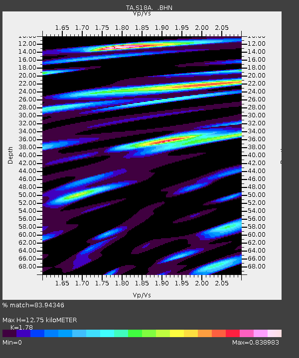
S18A Hurst Farm, Blanding, UT, USA - Earthquake Result Viewer
| Earthquake location: |
Southern Bolivia |
| Earthquake latitude/longitude: |
-20.1/-65.0 |
| Earthquake time(UTC): |
2008/10/12 (286) 20:55:41 GMT |
| Earthquake Depth: |
353 km |
| Earthquake Magnitude: |
6.0 MB, 6.2 MW, 6.2 MW |
| Earthquake Catalog/Contributor: |
WHDF/NEIC |
|
| Network: |
TA USArray Transportable Network (new EarthScope stations) |
| Station: |
S18A Hurst Farm, Blanding, UT, USA |
| Lat/Lon: |
37.69 N/109.99 W |
| Elevation: |
2351 m |
|
| Distance: |
71.4 deg |
| Az: |
323.697 deg |
| Baz: |
135.468 deg |
| Ray Param: |
0.053282637 |
| Estimated Moho Depth: |
12.75 km |
| Estimated Crust Vp/Vs: |
1.78 |
| Assumed Crust Vp: |
6.476 km/s |
| Estimated Crust Vs: |
3.638 km/s |
| Estimated Crust Poisson's Ratio: |
0.27 |
|
| Radial Match: |
83.94346 % |
| Radial Bump: |
400 |
| Transverse Match: |
67.19961 % |
| Transverse Bump: |
400 |
| SOD ConfigId: |
2556 |
| Insert Time: |
2010-03-06 14:53:30.445 +0000 |
| GWidth: |
2.5 |
| Max Bumps: |
400 |
| Tol: |
0.001 |
|

Signal To Noise
| Channel | StoN | STA | LTA |
| TA:S18A: :BHN:20081012T21:05:53.249001Z | 15.980754 | 2.3189737E-6 | 1.451104E-7 |
| TA:S18A: :BHE:20081012T21:05:53.249001Z | 6.1818037 | 9.716393E-7 | 1.5717731E-7 |
| TA:S18A: :BHZ:20081012T21:05:53.249001Z | 6.1121097 | 8.0026706E-7 | 1.309314E-7 |
| Arrivals |
| Ps | 1.6 SECOND |
| PpPs | 5.3 SECOND |
| PsPs/PpSs | 6.9 SECOND |


