You are here: Home > Network List > TA - USArray Transportable Network (new EarthScope stations) Stations List
> Station G21K Allakaket, AK, USA > Earthquake Result Viewer
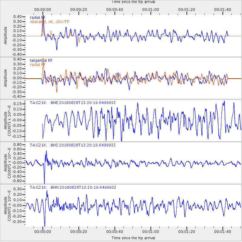
G21K Allakaket, AK, USA - Earthquake Result Viewer
*The percent match for this event was below the threshold and hence no stack was calculated.
| Earthquake location: |
Fiji Islands Region |
| Earthquake latitude/longitude: |
-18.0/-177.9 |
| Earthquake time(UTC): |
2018/08/28 (240) 13:09:10 GMT |
| Earthquake Depth: |
592 km |
| Earthquake Magnitude: |
5.7 Mww |
| Earthquake Catalog/Contributor: |
NEIC PDE/us |
|
| Network: |
TA USArray Transportable Network (new EarthScope stations) |
| Station: |
G21K Allakaket, AK, USA |
| Lat/Lon: |
66.52 N/153.51 W |
| Elevation: |
446 m |
|
| Distance: |
86.3 deg |
| Az: |
9.565 deg |
| Baz: |
203.235 deg |
| Ray Param: |
$rayparam |
*The percent match for this event was below the threshold and hence was not used in the summary stack. |
|
| Radial Match: |
67.26131 % |
| Radial Bump: |
400 |
| Transverse Match: |
65.15132 % |
| Transverse Bump: |
400 |
| SOD ConfigId: |
13570011 |
| Insert Time: |
2019-05-01 00:41:22.475 +0000 |
| GWidth: |
2.5 |
| Max Bumps: |
400 |
| Tol: |
0.001 |
|
Signal To Noise
| Channel | StoN | STA | LTA |
| TA:G21K: :BHZ:20180828T13:20:19.649993Z | 3.8319275 | 2.636287E-7 | 6.879793E-8 |
| TA:G21K: :BHN:20180828T13:20:19.649993Z | 2.7896514 | 1.4977873E-7 | 5.369084E-8 |
| TA:G21K: :BHE:20180828T13:20:19.649993Z | 1.3030077 | 7.258519E-8 | 5.5705883E-8 |
| Arrivals |
| Ps | |
| PpPs | |
| PsPs/PpSs | |


