You are here: Home > Network List > TA - USArray Transportable Network (new EarthScope stations) Stations List
> Station G31M Satah River, YT, CAN > Earthquake Result Viewer
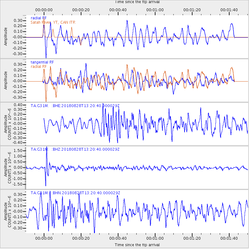
G31M Satah River, YT, CAN - Earthquake Result Viewer
*The percent match for this event was below the threshold and hence no stack was calculated.
| Earthquake location: |
Fiji Islands Region |
| Earthquake latitude/longitude: |
-18.0/-177.9 |
| Earthquake time(UTC): |
2018/08/28 (240) 13:09:10 GMT |
| Earthquake Depth: |
592 km |
| Earthquake Magnitude: |
5.7 Mww |
| Earthquake Catalog/Contributor: |
NEIC PDE/us |
|
| Network: |
TA USArray Transportable Network (new EarthScope stations) |
| Station: |
G31M Satah River, YT, CAN |
| Lat/Lon: |
66.92 N/134.27 W |
| Elevation: |
61 m |
|
| Distance: |
90.7 deg |
| Az: |
15.798 deg |
| Baz: |
221.08 deg |
| Ray Param: |
$rayparam |
*The percent match for this event was below the threshold and hence was not used in the summary stack. |
|
| Radial Match: |
62.360374 % |
| Radial Bump: |
400 |
| Transverse Match: |
60.0495 % |
| Transverse Bump: |
400 |
| SOD ConfigId: |
13570011 |
| Insert Time: |
2019-05-01 00:41:26.967 +0000 |
| GWidth: |
2.5 |
| Max Bumps: |
400 |
| Tol: |
0.001 |
|
Signal To Noise
| Channel | StoN | STA | LTA |
| TA:G31M: :BHZ:20180828T13:20:40.000029Z | 5.973997 | 5.954309E-7 | 9.967044E-8 |
| TA:G31M: :BHN:20180828T13:20:40.000029Z | 2.4051282 | 1.6975615E-7 | 7.058092E-8 |
| TA:G31M: :BHE:20180828T13:20:40.000029Z | 2.1796541 | 1.862819E-7 | 8.546397E-8 |
| Arrivals |
| Ps | |
| PpPs | |
| PsPs/PpSs | |


