You are here: Home > Network List > TA - USArray Transportable Network (new EarthScope stations) Stations List
> Station S18A Hurst Farm, Blanding, UT, USA > Earthquake Result Viewer
S18A Hurst Farm, Blanding, UT, USA - Earthquake Result Viewer

| Earthquake location: |
Andreanof Islands, Aleutian Is. |
| Earthquake latitude/longitude: |
52.2/-178.7 |
| Earthquake time(UTC): |
2008/03/22 (082) 21:24:11 GMT |
| Earthquake Depth: |
132 km |
| Earthquake Magnitude: |
5.8 MB, 6.2 MW, 6.1 MW |
| Earthquake Catalog/Contributor: |
WHDF/NEIC |
|
| Network: |
TA USArray Transportable Network (new EarthScope stations) |
| Station: |
S18A Hurst Farm, Blanding, UT, USA |
| Lat/Lon: |
37.69 N/109.99 W |
| Elevation: |
2351 m |
|
| Distance: |
48.9 deg |
| Az: |
78.672 deg |
| Baz: |
310.436 deg |
| Ray Param: |
0.06857601 |
| Estimated Moho Depth: |
42.5 km |
| Estimated Crust Vp/Vs: |
1.94 |
| Assumed Crust Vp: |
6.476 km/s |
| Estimated Crust Vs: |
3.338 km/s |
| Estimated Crust Poisson's Ratio: |
0.32 |
|
| Radial Match: |
86.53856 % |
| Radial Bump: |
400 |
| Transverse Match: |
72.209656 % |
| Transverse Bump: |
400 |
| SOD ConfigId: |
2564 |
| Insert Time: |
2010-03-06 14:53:40.608 +0000 |
| GWidth: |
2.5 |
| Max Bumps: |
400 |
| Tol: |
0.001 |
|
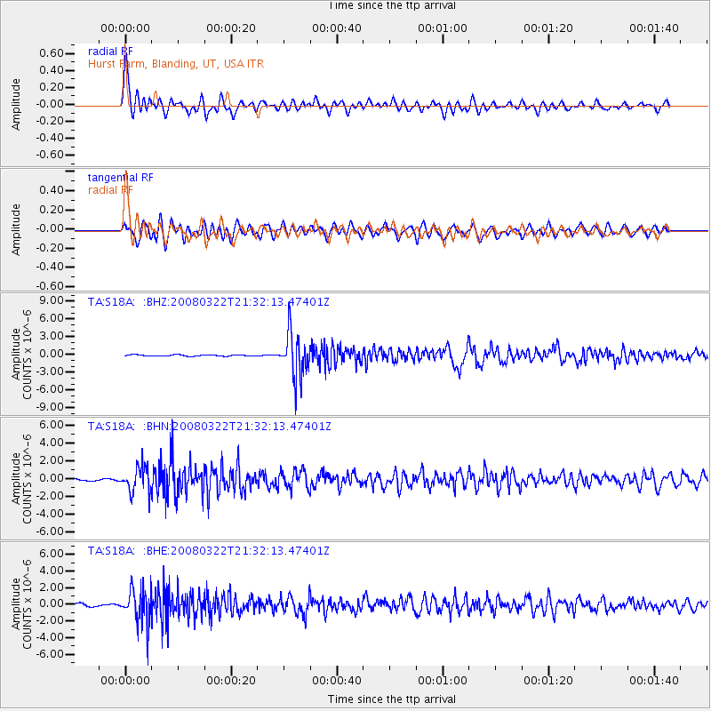
Signal To Noise
| Channel | StoN | STA | LTA |
| TA:S18A: :BHN:20080322T21:32:13.47401Z | 7.702677 | 1.4680116E-6 | 1.9058461E-7 |
| TA:S18A: :BHE:20080322T21:32:13.47401Z | 12.111833 | 2.0222426E-6 | 1.6696421E-7 |
| TA:S18A: :BHZ:20080322T21:32:13.47401Z | 34.98796 | 3.7123173E-6 | 1.0610271E-7 |
| Arrivals |
| Ps | 6.5 SECOND |
| PpPs | 18 SECOND |
| PsPs/PpSs | 25 SECOND |


