You are here: Home > Network List > UW - Pacific Northwest Regional Seismic Network Stations List
> Station HOOD Mt Hood Meadows, OR CREST BB SMO > Earthquake Result Viewer
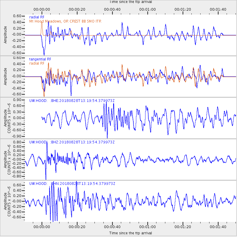
HOOD Mt Hood Meadows, OR CREST BB SMO - Earthquake Result Viewer
*The percent match for this event was below the threshold and hence no stack was calculated.
| Earthquake location: |
Fiji Islands Region |
| Earthquake latitude/longitude: |
-18.0/-177.9 |
| Earthquake time(UTC): |
2018/08/28 (240) 13:09:10 GMT |
| Earthquake Depth: |
592 km |
| Earthquake Magnitude: |
5.7 Mww |
| Earthquake Catalog/Contributor: |
NEIC PDE/us |
|
| Network: |
UW Pacific Northwest Regional Seismic Network |
| Station: |
HOOD Mt Hood Meadows, OR CREST BB SMO |
| Lat/Lon: |
45.32 N/121.65 W |
| Elevation: |
1520 m |
|
| Distance: |
81.1 deg |
| Az: |
36.444 deg |
| Baz: |
233.239 deg |
| Ray Param: |
$rayparam |
*The percent match for this event was below the threshold and hence was not used in the summary stack. |
|
| Radial Match: |
69.12968 % |
| Radial Bump: |
400 |
| Transverse Match: |
66.6789 % |
| Transverse Bump: |
400 |
| SOD ConfigId: |
13570011 |
| Insert Time: |
2019-05-01 00:43:30.759 +0000 |
| GWidth: |
2.5 |
| Max Bumps: |
400 |
| Tol: |
0.001 |
|
Signal To Noise
| Channel | StoN | STA | LTA |
| UW:HOOD: :BHZ:20180828T13:19:54.379973Z | 1.9353677 | 3.169105E-7 | 1.6374693E-7 |
| UW:HOOD: :BHN:20180828T13:19:54.379973Z | 1.524184 | 2.3694133E-7 | 1.5545454E-7 |
| UW:HOOD: :BHE:20180828T13:19:54.379973Z | 0.72733015 | 1.5167026E-7 | 2.0853015E-7 |
| Arrivals |
| Ps | |
| PpPs | |
| PsPs/PpSs | |


