You are here: Home > Network List > TA - USArray Transportable Network (new EarthScope stations) Stations List
> Station S18A Hurst Farm, Blanding, UT, USA > Earthquake Result Viewer
S18A Hurst Farm, Blanding, UT, USA - Earthquake Result Viewer

| Earthquake location: |
Solomon Islands |
| Earthquake latitude/longitude: |
-9.8/159.5 |
| Earthquake time(UTC): |
2007/08/16 (228) 08:39:27 GMT |
| Earthquake Depth: |
10 km |
| Earthquake Magnitude: |
6.1 MB, 6.7 MS, 6.4 MW |
| Earthquake Catalog/Contributor: |
WHDF/NEIC |
|
| Network: |
TA USArray Transportable Network (new EarthScope stations) |
| Station: |
S18A Hurst Farm, Blanding, UT, USA |
| Lat/Lon: |
37.69 N/109.99 W |
| Elevation: |
2351 m |
|
| Distance: |
96.4 deg |
| Az: |
52.956 deg |
| Baz: |
262.547 deg |
| Ray Param: |
0.040540025 |
| Estimated Moho Depth: |
50.25 km |
| Estimated Crust Vp/Vs: |
1.95 |
| Assumed Crust Vp: |
6.476 km/s |
| Estimated Crust Vs: |
3.317 km/s |
| Estimated Crust Poisson's Ratio: |
0.32 |
|
| Radial Match: |
90.41007 % |
| Radial Bump: |
400 |
| Transverse Match: |
73.70975 % |
| Transverse Bump: |
400 |
| SOD ConfigId: |
2564 |
| Insert Time: |
2010-03-06 14:54:17.457 +0000 |
| GWidth: |
2.5 |
| Max Bumps: |
400 |
| Tol: |
0.001 |
|
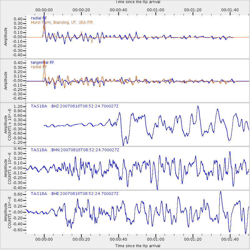
Signal To Noise
| Channel | StoN | STA | LTA |
| TA:S18A: :BHN:20070816T08:52:24.700027Z | 0.9426757 | 4.0372303E-8 | 4.282735E-8 |
| TA:S18A: :BHE:20070816T08:52:24.700027Z | 1.297986 | 5.900062E-8 | 4.5455515E-8 |
| TA:S18A: :BHZ:20070816T08:52:24.700027Z | 2.0747182 | 1.2989375E-7 | 6.26079E-8 |
| Arrivals |
| Ps | 7.5 SECOND |
| PpPs | 23 SECOND |
| PsPs/PpSs | 30 SECOND |


