You are here: Home > Network List > TA - USArray Transportable Network (new EarthScope stations) Stations List
> Station S18A Hurst Farm, Blanding, UT, USA > Earthquake Result Viewer
S18A Hurst Farm, Blanding, UT, USA - Earthquake Result Viewer

| Earthquake location: |
Near Coast Of Peru |
| Earthquake latitude/longitude: |
-14.3/-76.1 |
| Earthquake time(UTC): |
2007/08/16 (228) 05:16:56 GMT |
| Earthquake Depth: |
23 km |
| Earthquake Magnitude: |
5.8 MB, 6.1 MS, 6.3 MW, 6.2 ML |
| Earthquake Catalog/Contributor: |
WHDF/NEIC |
|
| Network: |
TA USArray Transportable Network (new EarthScope stations) |
| Station: |
S18A Hurst Farm, Blanding, UT, USA |
| Lat/Lon: |
37.69 N/109.99 W |
| Elevation: |
2351 m |
|
| Distance: |
60.7 deg |
| Az: |
329.54 deg |
| Baz: |
141.719 deg |
| Ray Param: |
0.06132652 |
| Estimated Moho Depth: |
44.25 km |
| Estimated Crust Vp/Vs: |
1.82 |
| Assumed Crust Vp: |
6.476 km/s |
| Estimated Crust Vs: |
3.568 km/s |
| Estimated Crust Poisson's Ratio: |
0.28 |
|
| Radial Match: |
86.63257 % |
| Radial Bump: |
400 |
| Transverse Match: |
69.00656 % |
| Transverse Bump: |
400 |
| SOD ConfigId: |
2564 |
| Insert Time: |
2010-03-06 14:54:18.854 +0000 |
| GWidth: |
2.5 |
| Max Bumps: |
400 |
| Tol: |
0.001 |
|
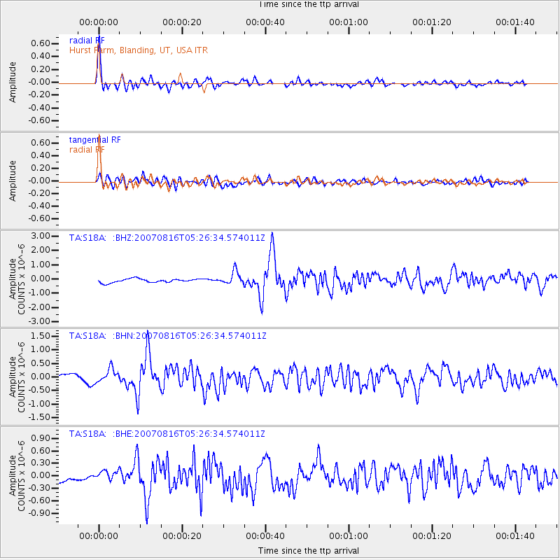
Signal To Noise
| Channel | StoN | STA | LTA |
| TA:S18A: :BHN:20070816T05:26:34.574011Z | 2.5241992 | 2.5421335E-7 | 1.00710494E-7 |
| TA:S18A: :BHE:20070816T05:26:34.574011Z | 1.5512061 | 1.3489209E-7 | 8.695949E-8 |
| TA:S18A: :BHZ:20070816T05:26:34.574011Z | 3.5666406 | 4.7033922E-7 | 1.3187177E-7 |
| Arrivals |
| Ps | 5.8 SECOND |
| PpPs | 18 SECOND |
| PsPs/PpSs | 24 SECOND |


