You are here: Home > Network List > TA - USArray Transportable Network (new EarthScope stations) Stations List
> Station S18A Hurst Farm, Blanding, UT, USA > Earthquake Result Viewer
S18A Hurst Farm, Blanding, UT, USA - Earthquake Result Viewer
| Earthquake location: |
Near Coast Of Peru |
| Earthquake latitude/longitude: |
-13.3/-76.5 |
| Earthquake time(UTC): |
2007/08/16 (228) 00:02:41 GMT |
| Earthquake Depth: |
40 km |
| Earthquake Magnitude: |
5.6 MB |
| Earthquake Catalog/Contributor: |
WHDF/NEIC |
|
| Network: |
TA USArray Transportable Network (new EarthScope stations) |
| Station: |
S18A Hurst Farm, Blanding, UT, USA |
| Lat/Lon: |
37.69 N/109.99 W |
| Elevation: |
2351 m |
|
| Distance: |
59.6 deg |
| Az: |
329.502 deg |
| Baz: |
141.471 deg |
| Ray Param: |
0.06197523 |
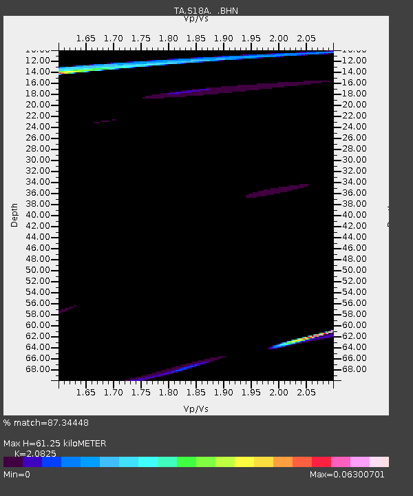
| Estimated Moho Depth: |
61.25 km |
| Estimated Crust Vp/Vs: |
2.08 |
| Assumed Crust Vp: |
6.476 km/s |
| Estimated Crust Vs: |
3.11 km/s |
| Estimated Crust Poisson's Ratio: |
0.35 |
|
| Radial Match: |
87.34448 % |
| Radial Bump: |
392 |
| Transverse Match: |
78.75548 % |
| Transverse Bump: |
306 |
| SOD ConfigId: |
2564 |
| Insert Time: |
2010-03-06 14:54:20.283 +0000 |
| GWidth: |
2.5 |
| Max Bumps: |
400 |
| Tol: |
0.001 |
|

Signal To Noise
| Channel | StoN | STA | LTA |
| TA:S18A: :BHN:20070816T00:12:10.624001Z | 0.83118206 | 3.3123237E-5 | 3.9850762E-5 |
| TA:S18A: :BHE:20070816T00:12:10.624001Z | 2.6495588 | 7.913387E-5 | 2.9866811E-5 |
| TA:S18A: :BHZ:20070816T00:12:10.624001Z | 1.4064192 | 5.892793E-5 | 4.1899264E-5 |
| Arrivals |
| Ps | 11 SECOND |
| PpPs | 28 SECOND |
| PsPs/PpSs | 39 SECOND |


