You are here: Home > Network List > CI - Caltech Regional Seismic Network Stations List
> Station PDM Parker Dam, Lake Havasu City, AZ, USA > Earthquake Result Viewer
PDM Parker Dam, Lake Havasu City, AZ, USA - Earthquake Result Viewer
| Earthquake location: |
Kuril Islands |
| Earthquake latitude/longitude: |
46.0/151.5 |
| Earthquake time(UTC): |
2009/04/07 (097) 04:23:33 GMT |
| Earthquake Depth: |
31 km |
| Earthquake Magnitude: |
6.5 MB, 6.8 MS, 6.9 MW, 6.9 MW |
| Earthquake Catalog/Contributor: |
WHDF/NEIC |
|
| Network: |
CI Caltech Regional Seismic Network |
| Station: |
PDM Parker Dam, Lake Havasu City, AZ, USA |
| Lat/Lon: |
34.30 N/114.14 W |
| Elevation: |
144 m |
|
| Distance: |
68.9 deg |
| Az: |
62.193 deg |
| Baz: |
311.913 deg |
| Ray Param: |
0.055925187 |
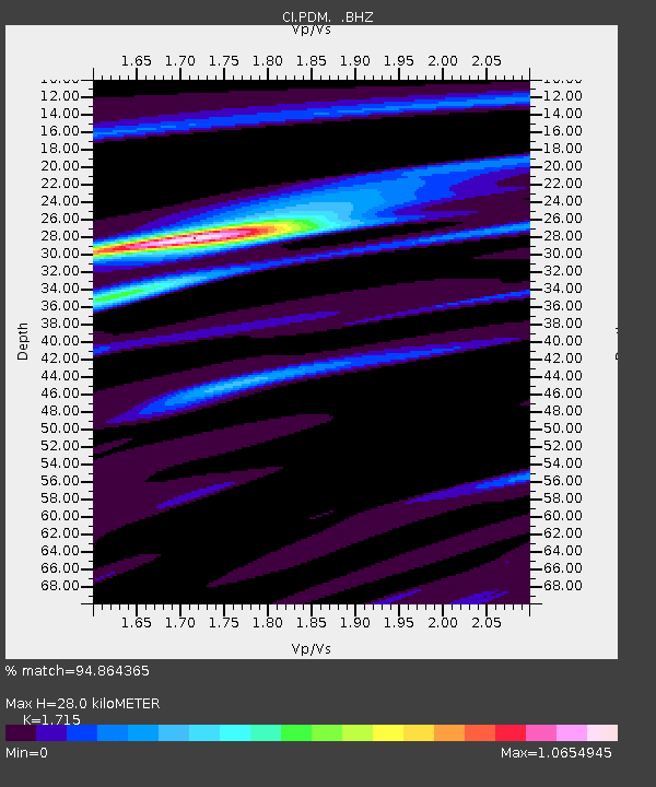
| Estimated Moho Depth: |
28.0 km |
| Estimated Crust Vp/Vs: |
1.72 |
| Assumed Crust Vp: |
6.276 km/s |
| Estimated Crust Vs: |
3.659 km/s |
| Estimated Crust Poisson's Ratio: |
0.24 |
|
| Radial Match: |
94.864365 % |
| Radial Bump: |
294 |
| Transverse Match: |
79.37999 % |
| Transverse Bump: |
400 |
| SOD ConfigId: |
2658 |
| Insert Time: |
2010-02-26 02:19:05.822 +0000 |
| GWidth: |
2.5 |
| Max Bumps: |
400 |
| Tol: |
0.001 |
|

Signal To Noise
| Channel | StoN | STA | LTA |
| CI:PDM: :BHZ:20090407T04:34:04.267004Z | 5.1445203 | 3.8157104E-6 | 7.4170384E-7 |
| CI:PDM: :BHN:20090407T04:34:04.267004Z | 3.6056242 | 1.2001648E-6 | 3.328591E-7 |
| CI:PDM: :BHE:20090407T04:34:04.267004Z | 2.0140526 | 9.350252E-7 | 4.6425066E-7 |
| Arrivals |
| Ps | 3.3 SECOND |
| PpPs | 12 SECOND |
| PsPs/PpSs | 15 SECOND |


