You are here: Home > Network List > GS - US Geological Survey Networks Stations List
> Station KAN10 Keim Farm > Earthquake Result Viewer
KAN10 Keim Farm - Earthquake Result Viewer
*The percent match for this event was below the threshold and hence no stack was calculated.
| Earthquake location: |
Tonga Islands |
| Earthquake latitude/longitude: |
-15.1/-173.2 |
| Earthquake time(UTC): |
2016/07/10 (192) 13:44:41 GMT |
| Earthquake Depth: |
10 km |
| Earthquake Magnitude: |
5.5 MB, 5.8 MWB |
| Earthquake Catalog/Contributor: |
NEIC PDE/NEIC COMCAT |
|
| Network: |
GS US Geological Survey Networks |
| Station: |
KAN10 Keim Farm |
| Lat/Lon: |
37.12 N/98.10 W |
| Elevation: |
417 m |
|
| Distance: |
87.5 deg |
| Az: |
50.641 deg |
| Baz: |
249.146 deg |
| Ray Param: |
$rayparam |
*The percent match for this event was below the threshold and hence was not used in the summary stack. |
|
| Radial Match: |
43.77054 % |
| Radial Bump: |
400 |
| Transverse Match: |
45.81811 % |
| Transverse Bump: |
400 |
| SOD ConfigId: |
1634031 |
| Insert Time: |
2016-07-24 13:52:59.815 +0000 |
| GWidth: |
2.5 |
| Max Bumps: |
400 |
| Tol: |
0.001 |
|
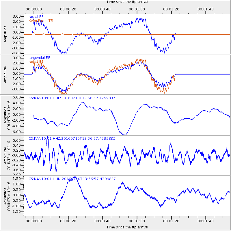
Signal To Noise
| Channel | StoN | STA | LTA |
| GS:KAN10:01:HHZ:20160710T13:56:57.429983Z | 1.5781027 | 1.3913117E-7 | 8.8163574E-8 |
| GS:KAN10:01:HHN:20160710T13:56:57.429983Z | 3.1706004 | 1.3215782E-6 | 4.168227E-7 |
| GS:KAN10:01:HHE:20160710T13:56:57.429983Z | 4.6936083 | 5.3084823E-6 | 1.1310025E-6 |
| Arrivals |
| Ps | |
| PpPs | |
| PsPs/PpSs | |


