You are here: Home > Network List > AE - Arizona Broadband Seismic Network Stations List
> Station PRCT Prescott > Earthquake Result Viewer
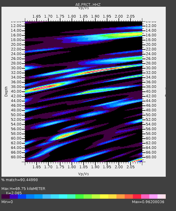
PRCT Prescott - Earthquake Result Viewer
| Earthquake location: |
Mariana Islands Region |
| Earthquake latitude/longitude: |
16.8/147.1 |
| Earthquake time(UTC): |
2018/08/28 (240) 22:35:14 GMT |
| Earthquake Depth: |
53 km |
| Earthquake Magnitude: |
6.6 Mi |
| Earthquake Catalog/Contributor: |
NEIC PDE/at |
|
| Network: |
AE Arizona Broadband Seismic Network |
| Station: |
PRCT Prescott |
| Lat/Lon: |
35.06 N/112.71 W |
| Elevation: |
1410 m |
|
| Distance: |
88.6 deg |
| Az: |
53.874 deg |
| Baz: |
289.43 deg |
| Ray Param: |
0.042409413 |
| Estimated Moho Depth: |
69.75 km |
| Estimated Crust Vp/Vs: |
2.07 |
| Assumed Crust Vp: |
6.276 km/s |
| Estimated Crust Vs: |
3.039 km/s |
| Estimated Crust Poisson's Ratio: |
0.35 |
|
| Radial Match: |
90.44998 % |
| Radial Bump: |
400 |
| Transverse Match: |
82.89127 % |
| Transverse Bump: |
400 |
| SOD ConfigId: |
13570011 |
| Insert Time: |
2019-05-01 00:47:36.426 +0000 |
| GWidth: |
2.5 |
| Max Bumps: |
400 |
| Tol: |
0.001 |
|

Signal To Noise
| Channel | StoN | STA | LTA |
| AE:PRCT: :HHZ:20180828T22:47:29.919983Z | 30.131317 | 2.0674322E-6 | 6.861407E-8 |
| AE:PRCT: :HHN:20180828T22:47:29.919983Z | 6.8698244 | 3.7072087E-7 | 5.396366E-8 |
| AE:PRCT: :HHE:20180828T22:47:29.919983Z | 8.6881895 | 8.232817E-7 | 9.475872E-8 |
| Arrivals |
| Ps | 12 SECOND |
| PpPs | 33 SECOND |
| PsPs/PpSs | 46 SECOND |


