You are here: Home > Network List > TA - USArray Transportable Network (new EarthScope stations) Stations List
> Station S18A Hurst Farm, Blanding, UT, USA > Earthquake Result Viewer
S18A Hurst Farm, Blanding, UT, USA - Earthquake Result Viewer
| Earthquake location: |
Andreanof Islands, Aleutian Is. |
| Earthquake latitude/longitude: |
51.9/-179.4 |
| Earthquake time(UTC): |
2008/04/15 (106) 22:59:51 GMT |
| Earthquake Depth: |
10 km |
| Earthquake Magnitude: |
6.1 MB, 6.4 MS, 6.4 MW, 6.4 MW |
| Earthquake Catalog/Contributor: |
WHDF/NEIC |
|
| Network: |
TA USArray Transportable Network (new EarthScope stations) |
| Station: |
S18A Hurst Farm, Blanding, UT, USA |
| Lat/Lon: |
37.69 N/109.99 W |
| Elevation: |
2351 m |
|
| Distance: |
49.4 deg |
| Az: |
77.964 deg |
| Baz: |
310.125 deg |
| Ray Param: |
0.06873461 |
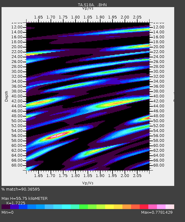
| Estimated Moho Depth: |
55.75 km |
| Estimated Crust Vp/Vs: |
1.72 |
| Assumed Crust Vp: |
6.476 km/s |
| Estimated Crust Vs: |
3.76 km/s |
| Estimated Crust Poisson's Ratio: |
0.25 |
|
| Radial Match: |
90.36595 % |
| Radial Bump: |
400 |
| Transverse Match: |
83.94997 % |
| Transverse Bump: |
400 |
| SOD ConfigId: |
2504 |
| Insert Time: |
2010-03-06 14:55:08.173 +0000 |
| GWidth: |
2.5 |
| Max Bumps: |
400 |
| Tol: |
0.001 |
|

Signal To Noise
| Channel | StoN | STA | LTA |
| TA:S18A: :BHN:20080415T23:08:10.050012Z | 11.854082 | 2.2600439E-6 | 1.9065533E-7 |
| TA:S18A: :BHE:20080415T23:08:10.050012Z | 3.7537615 | 7.765936E-7 | 2.068841E-7 |
| TA:S18A: :BHZ:20080415T23:08:10.050012Z | 3.766465 | 1.046787E-6 | 2.7792294E-7 |
| Arrivals |
| Ps | 6.6 SECOND |
| PpPs | 22 SECOND |
| PsPs/PpSs | 29 SECOND |


