You are here: Home > Network List > TA - USArray Transportable Network (new EarthScope stations) Stations List
> Station S18A Hurst Farm, Blanding, UT, USA > Earthquake Result Viewer
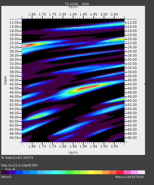
S18A Hurst Farm, Blanding, UT, USA - Earthquake Result Viewer
| Earthquake location: |
Andreanof Islands, Aleutian Is. |
| Earthquake latitude/longitude: |
51.9/-177.5 |
| Earthquake time(UTC): |
2008/05/02 (123) 01:33:37 GMT |
| Earthquake Depth: |
14 km |
| Earthquake Magnitude: |
6.3 MB, 6.8 MS, 6.6 MW, 6.6 MW |
| Earthquake Catalog/Contributor: |
WHDF/NEIC |
|
| Network: |
TA USArray Transportable Network (new EarthScope stations) |
| Station: |
S18A Hurst Farm, Blanding, UT, USA |
| Lat/Lon: |
37.69 N/109.99 W |
| Elevation: |
2351 m |
|
| Distance: |
48.3 deg |
| Az: |
79.212 deg |
| Baz: |
309.839 deg |
| Ray Param: |
0.06945844 |
| Estimated Moho Depth: |
23.0 km |
| Estimated Crust Vp/Vs: |
1.60 |
| Assumed Crust Vp: |
6.476 km/s |
| Estimated Crust Vs: |
4.047 km/s |
| Estimated Crust Poisson's Ratio: |
0.18 |
|
| Radial Match: |
92.34476 % |
| Radial Bump: |
400 |
| Transverse Match: |
80.91722 % |
| Transverse Bump: |
400 |
| SOD ConfigId: |
2504 |
| Insert Time: |
2010-03-06 14:55:10.949 +0000 |
| GWidth: |
2.5 |
| Max Bumps: |
400 |
| Tol: |
0.001 |
|

Signal To Noise
| Channel | StoN | STA | LTA |
| TA:S18A: :BHN:20080502T01:41:46.775004Z | 9.04191 | 1.8801901E-6 | 2.079417E-7 |
| TA:S18A: :BHE:20080502T01:41:46.775004Z | 3.5642183 | 7.282589E-7 | 2.04325E-7 |
| TA:S18A: :BHZ:20080502T01:41:46.775004Z | 4.6252437 | 6.017027E-7 | 1.3009102E-7 |
| Arrivals |
| Ps | 2.3 SECOND |
| PpPs | 8.6 SECOND |
| PsPs/PpSs | 11 SECOND |


