You are here: Home > Network List > AV - Alaska Volcano Observatory Stations List
> Station AU22 Augustine Mound, Augustine Volcano, Alaska > Earthquake Result Viewer
AU22 Augustine Mound, Augustine Volcano, Alaska - Earthquake Result Viewer
| Earthquake location: |
Mariana Islands Region |
| Earthquake latitude/longitude: |
16.8/147.1 |
| Earthquake time(UTC): |
2018/08/28 (240) 22:35:14 GMT |
| Earthquake Depth: |
53 km |
| Earthquake Magnitude: |
6.6 Mi |
| Earthquake Catalog/Contributor: |
NEIC PDE/at |
|
| Network: |
AV Alaska Volcano Observatory |
| Station: |
AU22 Augustine Mound, Augustine Volcano, Alaska |
| Lat/Lon: |
59.34 N/153.36 W |
| Elevation: |
105 m |
|
| Distance: |
60.3 deg |
| Az: |
30.573 deg |
| Baz: |
251.912 deg |
| Ray Param: |
0.06150182 |
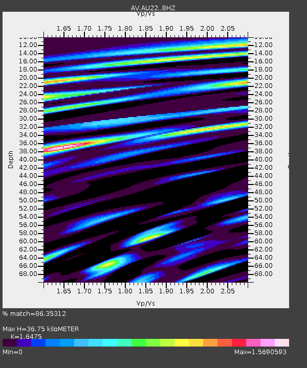
| Estimated Moho Depth: |
36.75 km |
| Estimated Crust Vp/Vs: |
1.65 |
| Assumed Crust Vp: |
5.989 km/s |
| Estimated Crust Vs: |
3.635 km/s |
| Estimated Crust Poisson's Ratio: |
0.21 |
|
| Radial Match: |
86.35312 % |
| Radial Bump: |
400 |
| Transverse Match: |
85.88674 % |
| Transverse Bump: |
400 |
| SOD ConfigId: |
13570011 |
| Insert Time: |
2019-05-01 00:49:19.763 +0000 |
| GWidth: |
2.5 |
| Max Bumps: |
400 |
| Tol: |
0.001 |
|

Signal To Noise
| Channel | StoN | STA | LTA |
| AV:AU22: :BHZ:20180828T22:44:46.559021Z | 6.274831 | 4.21428E-6 | 6.7161653E-7 |
| AV:AU22: :BHN:20180828T22:44:46.559021Z | 1.1448785 | 1.2381637E-6 | 1.0814804E-6 |
| AV:AU22: :BHE:20180828T22:44:46.559021Z | 1.6328946 | 2.0703544E-6 | 1.2679045E-6 |
| Arrivals |
| Ps | 4.1 SECOND |
| PpPs | 16 SECOND |
| PsPs/PpSs | 20 SECOND |


