You are here: Home > Network List > AV - Alaska Volcano Observatory Stations List
> Station ISLZ Lazaref River, Shishaldin Volcano, Alaska > Earthquake Result Viewer
ISLZ Lazaref River, Shishaldin Volcano, Alaska - Earthquake Result Viewer
| Earthquake location: |
Mariana Islands Region |
| Earthquake latitude/longitude: |
16.8/147.1 |
| Earthquake time(UTC): |
2018/08/28 (240) 22:35:14 GMT |
| Earthquake Depth: |
53 km |
| Earthquake Magnitude: |
6.6 Mi |
| Earthquake Catalog/Contributor: |
NEIC PDE/at |
|
| Network: |
AV Alaska Volcano Observatory |
| Station: |
ISLZ Lazaref River, Shishaldin Volcano, Alaska |
| Lat/Lon: |
54.72 N/163.71 W |
| Elevation: |
634 m |
|
| Distance: |
53.3 deg |
| Az: |
33.185 deg |
| Baz: |
244.659 deg |
| Ray Param: |
0.06603197 |
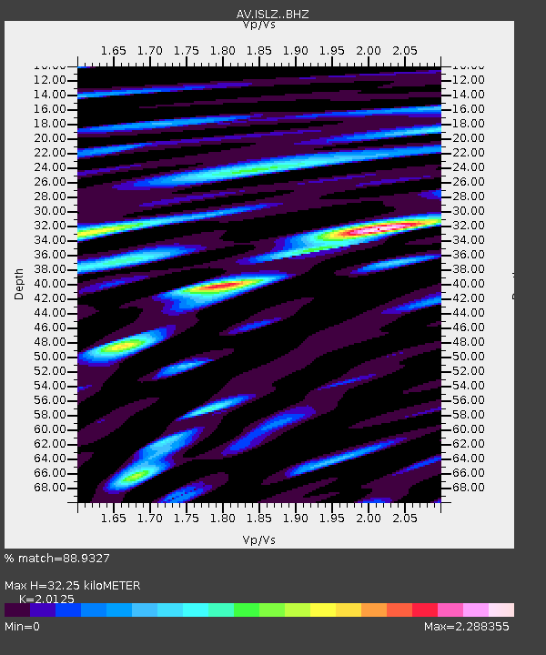
| Estimated Moho Depth: |
32.25 km |
| Estimated Crust Vp/Vs: |
2.01 |
| Assumed Crust Vp: |
5.989 km/s |
| Estimated Crust Vs: |
2.976 km/s |
| Estimated Crust Poisson's Ratio: |
0.34 |
|
| Radial Match: |
88.9327 % |
| Radial Bump: |
400 |
| Transverse Match: |
85.71209 % |
| Transverse Bump: |
400 |
| SOD ConfigId: |
13570011 |
| Insert Time: |
2019-05-01 00:49:27.091 +0000 |
| GWidth: |
2.5 |
| Max Bumps: |
400 |
| Tol: |
0.001 |
|

Signal To Noise
| Channel | StoN | STA | LTA |
| AV:ISLZ: :BHZ:20180828T22:43:57.419006Z | 15.883044 | 3.4460988E-6 | 2.1696714E-7 |
| AV:ISLZ: :BHN:20180828T22:43:57.419006Z | 3.9360647 | 1.2158279E-6 | 3.0889427E-7 |
| AV:ISLZ: :BHE:20180828T22:43:57.419006Z | 5.7115564 | 2.3928164E-6 | 4.1894296E-7 |
| Arrivals |
| Ps | 5.7 SECOND |
| PpPs | 16 SECOND |
| PsPs/PpSs | 21 SECOND |


