You are here: Home > Network List > AV - Alaska Volcano Observatory Stations List
> Station WACK Chichokna Glacier, Wrangell, Alaska > Earthquake Result Viewer
WACK Chichokna Glacier, Wrangell, Alaska - Earthquake Result Viewer
| Earthquake location: |
Mariana Islands Region |
| Earthquake latitude/longitude: |
16.8/147.1 |
| Earthquake time(UTC): |
2018/08/28 (240) 22:35:14 GMT |
| Earthquake Depth: |
53 km |
| Earthquake Magnitude: |
6.6 Mi |
| Earthquake Catalog/Contributor: |
NEIC PDE/at |
|
| Network: |
AV Alaska Volcano Observatory |
| Station: |
WACK Chichokna Glacier, Wrangell, Alaska |
| Lat/Lon: |
61.99 N/144.33 W |
| Elevation: |
2280 m |
|
| Distance: |
65.3 deg |
| Az: |
28.941 deg |
| Baz: |
259.027 deg |
| Ray Param: |
0.05827197 |
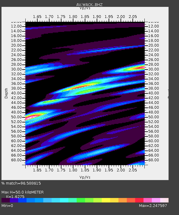
| Estimated Moho Depth: |
50.0 km |
| Estimated Crust Vp/Vs: |
1.63 |
| Assumed Crust Vp: |
6.566 km/s |
| Estimated Crust Vs: |
4.035 km/s |
| Estimated Crust Poisson's Ratio: |
0.20 |
|
| Radial Match: |
96.588615 % |
| Radial Bump: |
384 |
| Transverse Match: |
96.42248 % |
| Transverse Bump: |
346 |
| SOD ConfigId: |
13570011 |
| Insert Time: |
2019-05-01 00:49:51.712 +0000 |
| GWidth: |
2.5 |
| Max Bumps: |
400 |
| Tol: |
0.001 |
|

Signal To Noise
| Channel | StoN | STA | LTA |
| AV:WACK: :BHZ:20180828T22:45:19.359985Z | 49.03532 | 5.328059E-6 | 1.08657574E-7 |
| AV:WACK: :BHN:20180828T22:45:19.359985Z | 9.57687 | 1.9490349E-6 | 2.0351482E-7 |
| AV:WACK: :BHE:20180828T22:45:19.359985Z | 11.062424 | 2.4884046E-6 | 2.2494207E-7 |
| Arrivals |
| Ps | 5.0 SECOND |
| PpPs | 19 SECOND |
| PsPs/PpSs | 24 SECOND |


