You are here: Home > Network List > CC - Cascade Chain Volcano Monitoring Stations List
> Station SHRK Shell Rock, OR, USA > Earthquake Result Viewer
SHRK Shell Rock, OR, USA - Earthquake Result Viewer
| Earthquake location: |
Mariana Islands Region |
| Earthquake latitude/longitude: |
16.8/147.1 |
| Earthquake time(UTC): |
2018/08/28 (240) 22:35:14 GMT |
| Earthquake Depth: |
53 km |
| Earthquake Magnitude: |
6.6 Mi |
| Earthquake Catalog/Contributor: |
NEIC PDE/at |
|
| Network: |
CC Cascade Chain Volcano Monitoring |
| Station: |
SHRK Shell Rock, OR, USA |
| Lat/Lon: |
45.46 N/121.53 W |
| Elevation: |
1319 m |
|
| Distance: |
79.2 deg |
| Az: |
45.75 deg |
| Baz: |
282.85 deg |
| Ray Param: |
0.04904867 |
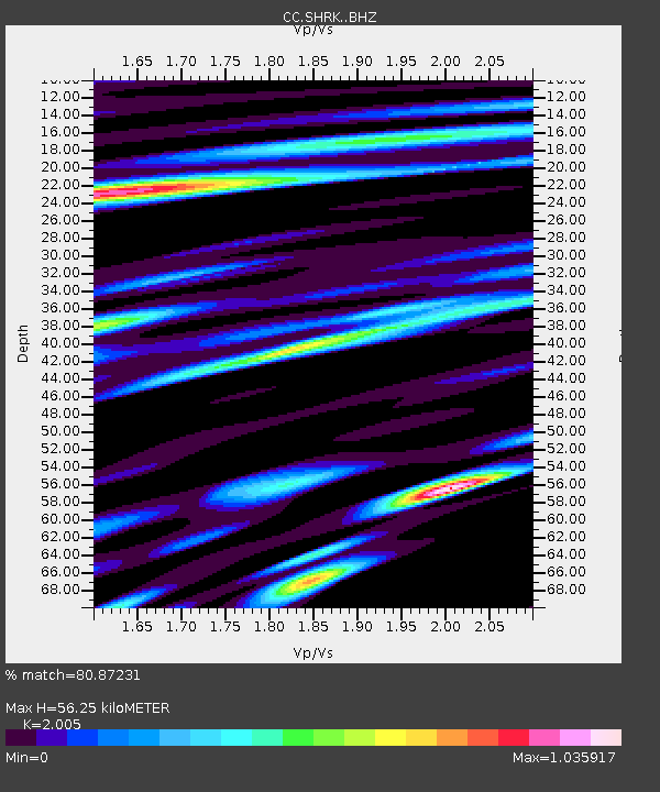
| Estimated Moho Depth: |
56.25 km |
| Estimated Crust Vp/Vs: |
2.01 |
| Assumed Crust Vp: |
6.597 km/s |
| Estimated Crust Vs: |
3.291 km/s |
| Estimated Crust Poisson's Ratio: |
0.33 |
|
| Radial Match: |
80.87231 % |
| Radial Bump: |
400 |
| Transverse Match: |
85.14764 % |
| Transverse Bump: |
400 |
| SOD ConfigId: |
13570011 |
| Insert Time: |
2019-05-01 00:50:30.628 +0000 |
| GWidth: |
2.5 |
| Max Bumps: |
400 |
| Tol: |
0.001 |
|

Signal To Noise
| Channel | StoN | STA | LTA |
| CC:SHRK: :BHZ:20180828T22:46:42.27002Z | 14.319984 | 4.0356886E-6 | 2.8182214E-7 |
| CC:SHRK: :BHN:20180828T22:46:42.27002Z | 5.6829977 | 7.742211E-7 | 1.3623463E-7 |
| CC:SHRK: :BHE:20180828T22:46:42.27002Z | 3.585541 | 1.1951391E-6 | 3.3332185E-7 |
| Arrivals |
| Ps | 8.8 SECOND |
| PpPs | 25 SECOND |
| PsPs/PpSs | 34 SECOND |


