You are here: Home > Network List > CN - Canadian National Seismograph Network Stations List
> Station ULM LAC DU BONNET, MB > Earthquake Result Viewer
ULM LAC DU BONNET, MB - Earthquake Result Viewer
| Earthquake location: |
Mariana Islands Region |
| Earthquake latitude/longitude: |
16.8/147.1 |
| Earthquake time(UTC): |
2018/08/28 (240) 22:35:14 GMT |
| Earthquake Depth: |
53 km |
| Earthquake Magnitude: |
6.6 Mi |
| Earthquake Catalog/Contributor: |
NEIC PDE/at |
|
| Network: |
CN Canadian National Seismograph Network |
| Station: |
ULM LAC DU BONNET, MB |
| Lat/Lon: |
50.25 N/95.88 W |
| Elevation: |
251 m |
|
| Distance: |
93.4 deg |
| Az: |
34.951 deg |
| Baz: |
301.267 deg |
| Ray Param: |
0.041246623 |
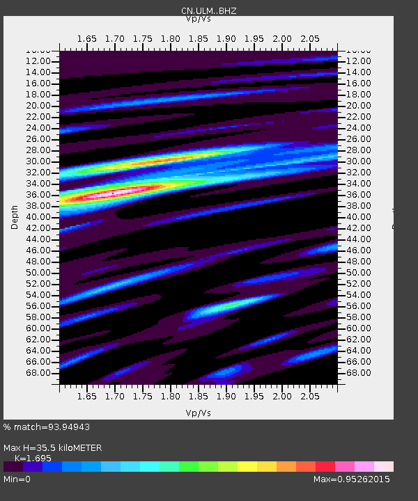
| Estimated Moho Depth: |
35.5 km |
| Estimated Crust Vp/Vs: |
1.70 |
| Assumed Crust Vp: |
6.459 km/s |
| Estimated Crust Vs: |
3.811 km/s |
| Estimated Crust Poisson's Ratio: |
0.23 |
|
| Radial Match: |
93.94943 % |
| Radial Bump: |
369 |
| Transverse Match: |
84.33856 % |
| Transverse Bump: |
400 |
| SOD ConfigId: |
13570011 |
| Insert Time: |
2019-05-01 00:51:53.543 +0000 |
| GWidth: |
2.5 |
| Max Bumps: |
400 |
| Tol: |
0.001 |
|

Signal To Noise
| Channel | StoN | STA | LTA |
| CN:ULM: :BHZ:20180828T22:47:52.000Z | 18.544933 | 1.1359812E-6 | 6.125561E-8 |
| CN:ULM: :BHN:20180828T22:47:52.000Z | 6.0113263 | 2.6306878E-7 | 4.3762185E-8 |
| CN:ULM: :BHE:20180828T22:47:52.000Z | 5.238662 | 2.9263447E-7 | 5.5860536E-8 |
| Arrivals |
| Ps | 3.9 SECOND |
| PpPs | 14 SECOND |
| PsPs/PpSs | 18 SECOND |


