You are here: Home > Network List > AG - Arkansas Seismic Network Stations List
> Station HHAR Hobbs,AR > Earthquake Result Viewer
HHAR Hobbs,AR - Earthquake Result Viewer
| Earthquake location: |
Near Coast Of Ecuador |
| Earthquake latitude/longitude: |
0.6/-79.6 |
| Earthquake time(UTC): |
2016/07/11 (193) 02:01:09 GMT |
| Earthquake Depth: |
14 km |
| Earthquake Magnitude: |
5.8 MWW, 5.7 MWB, 5.9 MWC |
| Earthquake Catalog/Contributor: |
NEIC PDE/NEIC COMCAT |
|
| Network: |
AG Arkansas Seismic Network |
| Station: |
HHAR Hobbs,AR |
| Lat/Lon: |
36.28 N/93.94 W |
| Elevation: |
421 m |
|
| Distance: |
37.9 deg |
| Az: |
341.06 deg |
| Baz: |
156.317 deg |
| Ray Param: |
0.07584732 |
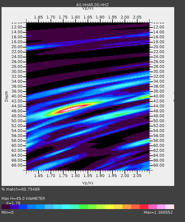
| Estimated Moho Depth: |
45.0 km |
| Estimated Crust Vp/Vs: |
1.78 |
| Assumed Crust Vp: |
6.53 km/s |
| Estimated Crust Vs: |
3.669 km/s |
| Estimated Crust Poisson's Ratio: |
0.27 |
|
| Radial Match: |
80.75469 % |
| Radial Bump: |
400 |
| Transverse Match: |
52.06657 % |
| Transverse Bump: |
400 |
| SOD ConfigId: |
1634031 |
| Insert Time: |
2016-07-25 02:01:26.839 +0000 |
| GWidth: |
2.5 |
| Max Bumps: |
400 |
| Tol: |
0.001 |
|

Signal To Noise
| Channel | StoN | STA | LTA |
| AG:HHAR:00:HHZ:20160711T02:07:55.440Z | 11.365851 | 6.0601E-7 | 5.331849E-8 |
| AG:HHAR:00:HHN:20160711T02:07:55.440Z | 3.9683273 | 2.9741247E-7 | 7.4946556E-8 |
| AG:HHAR:00:HHE:20160711T02:07:55.440Z | 2.0693362 | 2.647898E-7 | 1.2795883E-7 |
| Arrivals |
| Ps | 5.8 SECOND |
| PpPs | 18 SECOND |
| PsPs/PpSs | 24 SECOND |


