You are here: Home > Network List > AG - Arkansas Seismic Network Stations List
> Station X40A Basin Creek Farm, Marlvern, AR > Earthquake Result Viewer
X40A Basin Creek Farm, Marlvern, AR - Earthquake Result Viewer
| Earthquake location: |
Near Coast Of Ecuador |
| Earthquake latitude/longitude: |
0.6/-79.6 |
| Earthquake time(UTC): |
2016/07/11 (193) 02:01:09 GMT |
| Earthquake Depth: |
14 km |
| Earthquake Magnitude: |
5.8 MWW, 5.7 MWB, 5.9 MWC |
| Earthquake Catalog/Contributor: |
NEIC PDE/NEIC COMCAT |
|
| Network: |
AG Arkansas Seismic Network |
| Station: |
X40A Basin Creek Farm, Marlvern, AR |
| Lat/Lon: |
34.49 N/92.83 W |
| Elevation: |
158 m |
|
| Distance: |
35.9 deg |
| Az: |
341.263 deg |
| Baz: |
157.117 deg |
| Ray Param: |
0.07695037 |
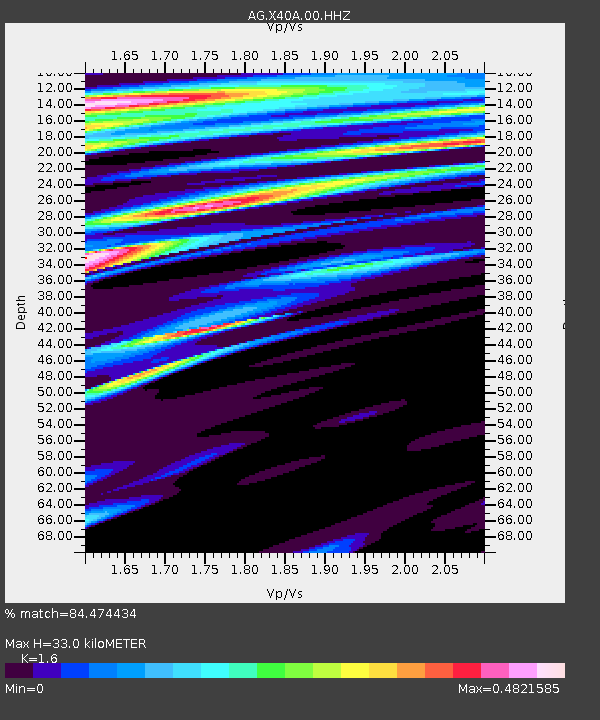
| Estimated Moho Depth: |
33.0 km |
| Estimated Crust Vp/Vs: |
1.60 |
| Assumed Crust Vp: |
6.498 km/s |
| Estimated Crust Vs: |
4.061 km/s |
| Estimated Crust Poisson's Ratio: |
0.18 |
|
| Radial Match: |
84.474434 % |
| Radial Bump: |
386 |
| Transverse Match: |
87.10835 % |
| Transverse Bump: |
400 |
| SOD ConfigId: |
1634031 |
| Insert Time: |
2016-07-25 02:01:45.258 +0000 |
| GWidth: |
2.5 |
| Max Bumps: |
400 |
| Tol: |
0.001 |
|
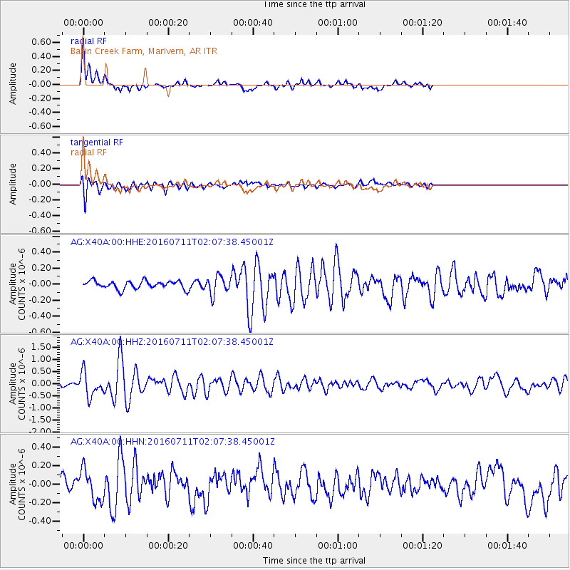
Signal To Noise
| Channel | StoN | STA | LTA |
| AG:X40A:00:HHZ:20160711T02:07:38.45001Z | 7.0716295 | 4.991017E-7 | 7.057803E-8 |
| AG:X40A:00:HHN:20160711T02:07:38.45001Z | 3.6105962 | 1.7235867E-7 | 4.77369E-8 |
| AG:X40A:00:HHE:20160711T02:07:38.45001Z | 2.350042 | 1.16306246E-7 | 4.9491135E-8 |
| Arrivals |
| Ps | 3.3 SECOND |
| PpPs | 12 SECOND |
| PsPs/PpSs | 15 SECOND |


