You are here: Home > Network List > NN - Western Great Basin/Eastern Sierra Nevada Stations List
> Station RYN Ryan, Nevada w84,gps > Earthquake Result Viewer
RYN Ryan, Nevada w84,gps - Earthquake Result Viewer
| Earthquake location: |
Mariana Islands Region |
| Earthquake latitude/longitude: |
16.8/147.1 |
| Earthquake time(UTC): |
2018/08/28 (240) 22:35:14 GMT |
| Earthquake Depth: |
53 km |
| Earthquake Magnitude: |
6.6 Mi |
| Earthquake Catalog/Contributor: |
NEIC PDE/at |
|
| Network: |
NN Western Great Basin/Eastern Sierra Nevada |
| Station: |
RYN Ryan, Nevada w84,gps |
| Lat/Lon: |
38.63 N/118.52 W |
| Elevation: |
1651 m |
|
| Distance: |
83.0 deg |
| Az: |
51.886 deg |
| Baz: |
285.811 deg |
| Ray Param: |
0.04638141 |
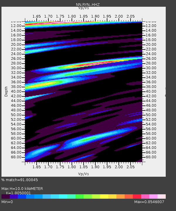
| Estimated Moho Depth: |
10.0 km |
| Estimated Crust Vp/Vs: |
1.81 |
| Assumed Crust Vp: |
6.279 km/s |
| Estimated Crust Vs: |
3.478 km/s |
| Estimated Crust Poisson's Ratio: |
0.28 |
|
| Radial Match: |
91.80845 % |
| Radial Bump: |
400 |
| Transverse Match: |
89.28271 % |
| Transverse Bump: |
400 |
| SOD ConfigId: |
13570011 |
| Insert Time: |
2019-05-01 00:53:49.122 +0000 |
| GWidth: |
2.5 |
| Max Bumps: |
400 |
| Tol: |
0.001 |
|

Signal To Noise
| Channel | StoN | STA | LTA |
| NN:RYN: :HHZ:20180828T22:47:02.765015Z | 41.697803 | 2.681082E-6 | 6.4297915E-8 |
| NN:RYN: :HHN:20180828T22:47:02.765015Z | 6.3625164 | 1.9820745E-7 | 3.1152368E-8 |
| NN:RYN: :HHE:20180828T22:47:02.765015Z | 14.118449 | 8.0257945E-7 | 5.6846147E-8 |
| Arrivals |
| Ps | 1.3 SECOND |
| PpPs | 4.4 SECOND |
| PsPs/PpSs | 5.7 SECOND |


