You are here: Home > Network List > CO - South Carolina Seismic Network Stations List
> Station HODGE CO:HODGE > Earthquake Result Viewer
HODGE CO:HODGE - Earthquake Result Viewer
| Earthquake location: |
Near Coast Of Ecuador |
| Earthquake latitude/longitude: |
0.6/-79.6 |
| Earthquake time(UTC): |
2016/07/11 (193) 02:01:09 GMT |
| Earthquake Depth: |
14 km |
| Earthquake Magnitude: |
5.8 MWW, 5.7 MWB, 5.9 MWC |
| Earthquake Catalog/Contributor: |
NEIC PDE/NEIC COMCAT |
|
| Network: |
CO South Carolina Seismic Network |
| Station: |
HODGE CO:HODGE |
| Lat/Lon: |
34.23 N/82.26 W |
| Elevation: |
151 m |
|
| Distance: |
33.6 deg |
| Az: |
356.083 deg |
| Baz: |
175.271 deg |
| Ray Param: |
0.078136735 |
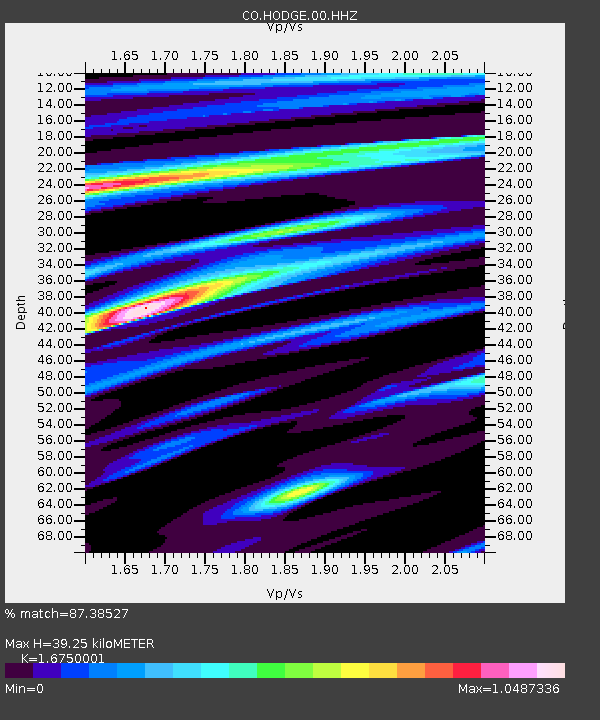
| Estimated Moho Depth: |
39.25 km |
| Estimated Crust Vp/Vs: |
1.68 |
| Assumed Crust Vp: |
6.35 km/s |
| Estimated Crust Vs: |
3.791 km/s |
| Estimated Crust Poisson's Ratio: |
0.22 |
|
| Radial Match: |
87.38527 % |
| Radial Bump: |
257 |
| Transverse Match: |
61.708332 % |
| Transverse Bump: |
400 |
| SOD ConfigId: |
1634031 |
| Insert Time: |
2016-07-25 02:02:54.123 +0000 |
| GWidth: |
2.5 |
| Max Bumps: |
400 |
| Tol: |
0.001 |
|

Signal To Noise
| Channel | StoN | STA | LTA |
| CO:HODGE:00:HHZ:20160711T02:07:18.190Z | 8.654941 | 7.778667E-7 | 8.9875456E-8 |
| CO:HODGE:00:HHN:20160711T02:07:18.190Z | 9.633899 | 5.2680093E-7 | 5.4682012E-8 |
| CO:HODGE:00:HHE:20160711T02:07:18.190Z | 1.313758 | 1.0140526E-7 | 7.718717E-8 |
| Arrivals |
| Ps | 4.5 SECOND |
| PpPs | 15 SECOND |
| PsPs/PpSs | 20 SECOND |


