You are here: Home > Network List > TA - USArray Transportable Network (new EarthScope stations) Stations List
> Station S18A Hurst Farm, Blanding, UT, USA > Earthquake Result Viewer
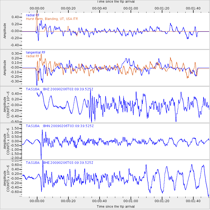
S18A Hurst Farm, Blanding, UT, USA - Earthquake Result Viewer
*The percent match for this event was below the threshold and hence no stack was calculated.
| Earthquake location: |
Near Coast Of Northern Chile |
| Earthquake latitude/longitude: |
-28.0/-71.1 |
| Earthquake time(UTC): |
2009/02/06 (037) 02:58:35 GMT |
| Earthquake Depth: |
52 km |
| Earthquake Magnitude: |
5.5 MB |
| Earthquake Catalog/Contributor: |
WHDF/NEIC |
|
| Network: |
TA USArray Transportable Network (new EarthScope stations) |
| Station: |
S18A Hurst Farm, Blanding, UT, USA |
| Lat/Lon: |
37.69 N/109.99 W |
| Elevation: |
2351 m |
|
| Distance: |
74.8 deg |
| Az: |
328.931 deg |
| Baz: |
144.879 deg |
| Ray Param: |
$rayparam |
*The percent match for this event was below the threshold and hence was not used in the summary stack. |
|
| Radial Match: |
54.763832 % |
| Radial Bump: |
400 |
| Transverse Match: |
56.09096 % |
| Transverse Bump: |
400 |
| SOD ConfigId: |
2658 |
| Insert Time: |
2010-03-06 14:56:29.280 +0000 |
| GWidth: |
2.5 |
| Max Bumps: |
400 |
| Tol: |
0.001 |
|
Signal To Noise
| Channel | StoN | STA | LTA |
| TA:S18A: :BHN:20090206T03:09:39.525Z | 2.8511987 | 6.561731E-7 | 2.3013936E-7 |
| TA:S18A: :BHE:20090206T03:09:39.525Z | 1.6035372 | 2.7727805E-7 | 1.7291651E-7 |
| TA:S18A: :BHZ:20090206T03:09:39.525Z | 1.0867066 | 2.1963592E-7 | 2.0211152E-7 |
| Arrivals |
| Ps | |
| PpPs | |
| PsPs/PpSs | |


