You are here: Home > Network List > TA - USArray Transportable Network (new EarthScope stations) Stations List
> Station A21K Barrow, AK, USA > Earthquake Result Viewer
A21K Barrow, AK, USA - Earthquake Result Viewer
| Earthquake location: |
Mariana Islands Region |
| Earthquake latitude/longitude: |
16.8/147.1 |
| Earthquake time(UTC): |
2018/08/28 (240) 22:35:14 GMT |
| Earthquake Depth: |
53 km |
| Earthquake Magnitude: |
6.6 Mi |
| Earthquake Catalog/Contributor: |
NEIC PDE/at |
|
| Network: |
TA USArray Transportable Network (new EarthScope stations) |
| Station: |
A21K Barrow, AK, USA |
| Lat/Lon: |
71.32 N/156.62 W |
| Elevation: |
577 m |
|
| Distance: |
63.7 deg |
| Az: |
17.395 deg |
| Baz: |
242.724 deg |
| Ray Param: |
0.05929583 |
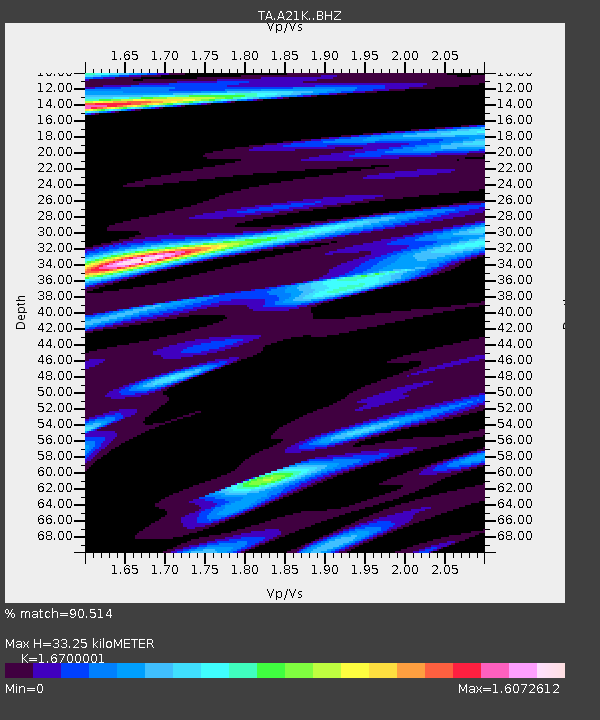
| Estimated Moho Depth: |
33.25 km |
| Estimated Crust Vp/Vs: |
1.67 |
| Assumed Crust Vp: |
6.048 km/s |
| Estimated Crust Vs: |
3.622 km/s |
| Estimated Crust Poisson's Ratio: |
0.22 |
|
| Radial Match: |
90.514 % |
| Radial Bump: |
400 |
| Transverse Match: |
80.81965 % |
| Transverse Bump: |
400 |
| SOD ConfigId: |
13570011 |
| Insert Time: |
2019-05-01 00:55:07.544 +0000 |
| GWidth: |
2.5 |
| Max Bumps: |
400 |
| Tol: |
0.001 |
|
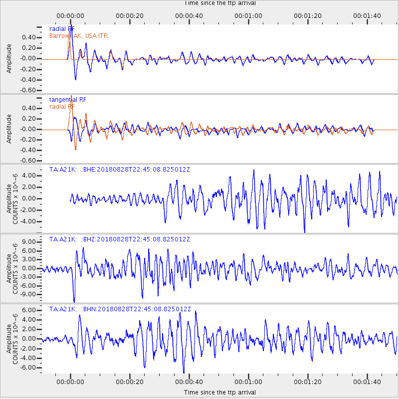
Signal To Noise
| Channel | StoN | STA | LTA |
| TA:A21K: :BHZ:20180828T22:45:08.825012Z | 7.967391 | 4.5607376E-6 | 5.724255E-7 |
| TA:A21K: :BHN:20180828T22:45:08.825012Z | 6.312063 | 2.2729203E-6 | 3.600915E-7 |
| TA:A21K: :BHE:20180828T22:45:08.825012Z | 3.061537 | 1.5979075E-6 | 5.2192985E-7 |
| Arrivals |
| Ps | 3.8 SECOND |
| PpPs | 14 SECOND |
| PsPs/PpSs | 18 SECOND |


