You are here: Home > Network List > TA - USArray Transportable Network (new EarthScope stations) Stations List
> Station A36M Sachs Harbour, NT, CAN > Earthquake Result Viewer
A36M Sachs Harbour, NT, CAN - Earthquake Result Viewer

| Earthquake location: |
Mariana Islands Region |
| Earthquake latitude/longitude: |
16.8/147.1 |
| Earthquake time(UTC): |
2018/08/28 (240) 22:35:14 GMT |
| Earthquake Depth: |
53 km |
| Earthquake Magnitude: |
6.6 Mi |
| Earthquake Catalog/Contributor: |
NEIC PDE/at |
|
| Network: |
TA USArray Transportable Network (new EarthScope stations) |
| Station: |
A36M Sachs Harbour, NT, CAN |
| Lat/Lon: |
71.99 N/125.25 W |
| Elevation: |
32 m |
|
| Distance: |
73.4 deg |
| Az: |
18.925 deg |
| Baz: |
273.115 deg |
| Ray Param: |
0.052906062 |
| Estimated Moho Depth: |
22.0 km |
| Estimated Crust Vp/Vs: |
1.84 |
| Assumed Crust Vp: |
6.24 km/s |
| Estimated Crust Vs: |
3.391 km/s |
| Estimated Crust Poisson's Ratio: |
0.29 |
|
| Radial Match: |
95.27525 % |
| Radial Bump: |
400 |
| Transverse Match: |
89.657646 % |
| Transverse Bump: |
400 |
| SOD ConfigId: |
13570011 |
| Insert Time: |
2019-05-01 00:55:07.708 +0000 |
| GWidth: |
2.5 |
| Max Bumps: |
400 |
| Tol: |
0.001 |
|
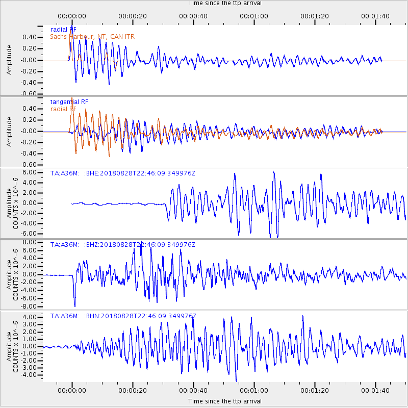
Signal To Noise
| Channel | StoN | STA | LTA |
| TA:A36M: :BHZ:20180828T22:46:09.349976Z | 55.012505 | 2.8553936E-6 | 5.1904447E-8 |
| TA:A36M: :BHN:20180828T22:46:09.349976Z | 3.7255144 | 3.4938626E-7 | 9.378201E-8 |
| TA:A36M: :BHE:20180828T22:46:09.349976Z | 15.471846 | 1.875422E-6 | 1.2121514E-7 |
| Arrivals |
| Ps | 3.1 SECOND |
| PpPs | 9.7 SECOND |
| PsPs/PpSs | 13 SECOND |


