You are here: Home > Network List > TA - USArray Transportable Network (new EarthScope stations) Stations List
> Station F14K Arctic Creek, AK, USA > Earthquake Result Viewer
F14K Arctic Creek, AK, USA - Earthquake Result Viewer
| Earthquake location: |
Mariana Islands Region |
| Earthquake latitude/longitude: |
16.8/147.1 |
| Earthquake time(UTC): |
2018/08/28 (240) 22:35:14 GMT |
| Earthquake Depth: |
53 km |
| Earthquake Magnitude: |
6.6 Mi |
| Earthquake Catalog/Contributor: |
NEIC PDE/at |
|
| Network: |
TA USArray Transportable Network (new EarthScope stations) |
| Station: |
F14K Arctic Creek, AK, USA |
| Lat/Lon: |
65.47 N/166.33 W |
| Elevation: |
266 m |
|
| Distance: |
57.6 deg |
| Az: |
21.042 deg |
| Baz: |
235.479 deg |
| Ray Param: |
0.06326664 |
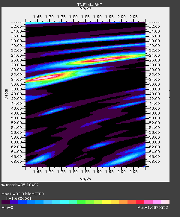
| Estimated Moho Depth: |
33.0 km |
| Estimated Crust Vp/Vs: |
1.68 |
| Assumed Crust Vp: |
6.307 km/s |
| Estimated Crust Vs: |
3.754 km/s |
| Estimated Crust Poisson's Ratio: |
0.23 |
|
| Radial Match: |
95.10497 % |
| Radial Bump: |
400 |
| Transverse Match: |
91.47918 % |
| Transverse Bump: |
400 |
| SOD ConfigId: |
13570011 |
| Insert Time: |
2019-05-01 00:55:39.264 +0000 |
| GWidth: |
2.5 |
| Max Bumps: |
400 |
| Tol: |
0.001 |
|
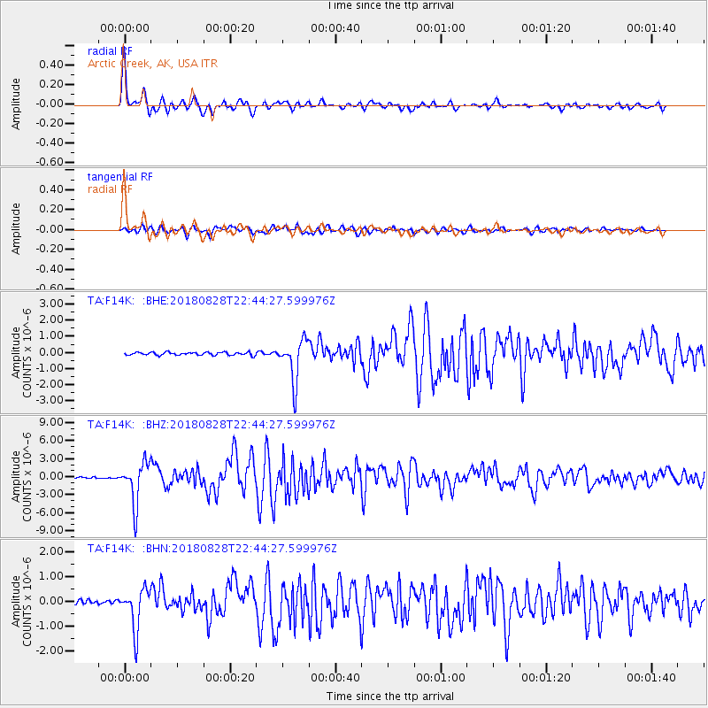
Signal To Noise
| Channel | StoN | STA | LTA |
| TA:F14K: :BHZ:20180828T22:44:27.599976Z | 38.08605 | 3.5210453E-6 | 9.2449746E-8 |
| TA:F14K: :BHN:20180828T22:44:27.599976Z | 10.822516 | 8.464943E-7 | 7.821603E-8 |
| TA:F14K: :BHE:20180828T22:44:27.599976Z | 14.269379 | 1.3246732E-6 | 9.283328E-8 |
| Arrivals |
| Ps | 3.7 SECOND |
| PpPs | 13 SECOND |
| PsPs/PpSs | 17 SECOND |


