You are here: Home > Network List > TA - USArray Transportable Network (new EarthScope stations) Stations List
> Station G21K Allakaket, AK, USA > Earthquake Result Viewer
G21K Allakaket, AK, USA - Earthquake Result Viewer
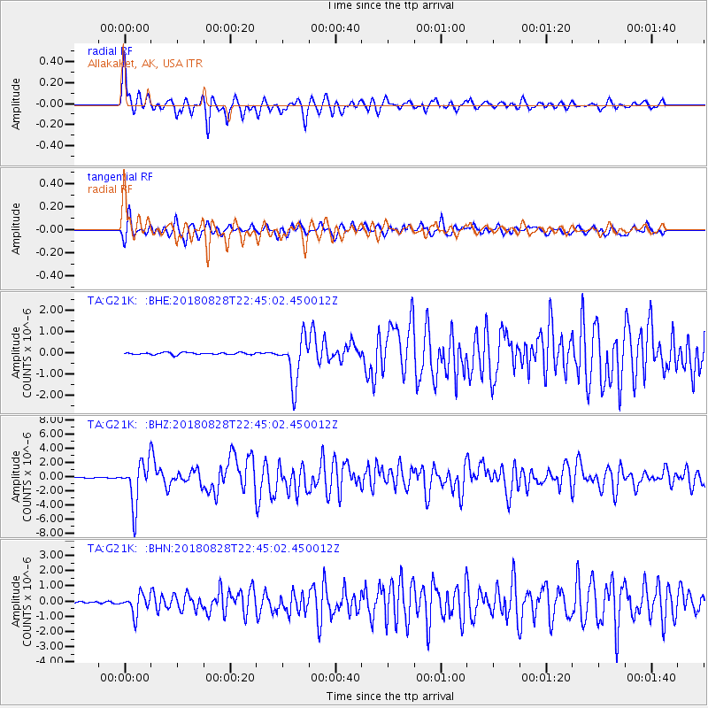
| Earthquake location: |
Mariana Islands Region |
| Earthquake latitude/longitude: |
16.8/147.1 |
| Earthquake time(UTC): |
2018/08/28 (240) 22:35:14 GMT |
| Earthquake Depth: |
53 km |
| Earthquake Magnitude: |
6.6 Mi |
| Earthquake Catalog/Contributor: |
NEIC PDE/at |
|
| Network: |
TA USArray Transportable Network (new EarthScope stations) |
| Station: |
G21K Allakaket, AK, USA |
| Lat/Lon: |
66.52 N/153.51 W |
| Elevation: |
446 m |
|
| Distance: |
62.7 deg |
| Az: |
22.84 deg |
| Baz: |
248.084 deg |
| Ray Param: |
0.059935935 |
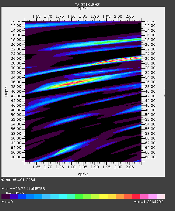
| Estimated Moho Depth: |
25.75 km |
| Estimated Crust Vp/Vs: |
2.05 |
| Assumed Crust Vp: |
6.455 km/s |
| Estimated Crust Vs: |
3.145 km/s |
| Estimated Crust Poisson's Ratio: |
0.34 |
|
| Radial Match: |
91.3254 % |
| Radial Bump: |
400 |
| Transverse Match: |
84.40444 % |
| Transverse Bump: |
400 |
| SOD ConfigId: |
13570011 |
| Insert Time: |
2019-05-01 00:55:54.321 +0000 |
| GWidth: |
2.5 |
| Max Bumps: |
400 |
| Tol: |
0.001 |
|
Signal To Noise
| Channel | StoN | STA | LTA |
| TA:G21K: :BHZ:20180828T22:45:02.450012Z | 53.911945 | 3.122805E-6 | 5.792418E-8 |
| TA:G21K: :BHN:20180828T22:45:02.450012Z | 9.64972 | 6.6233423E-7 | 6.863766E-8 |
| TA:G21K: :BHE:20180828T22:45:02.450012Z | 22.70039 | 1.0719372E-6 | 4.722109E-8 |
| Arrivals |
| Ps | 4.4 SECOND |
| PpPs | 12 SECOND |
| PsPs/PpSs | 16 SECOND |


