You are here: Home > Network List > TA - USArray Transportable Network (new EarthScope stations) Stations List
> Station H18K Honhosa River, AK, USA > Earthquake Result Viewer
H18K Honhosa River, AK, USA - Earthquake Result Viewer
| Earthquake location: |
Mariana Islands Region |
| Earthquake latitude/longitude: |
16.8/147.1 |
| Earthquake time(UTC): |
2018/08/28 (240) 22:35:14 GMT |
| Earthquake Depth: |
53 km |
| Earthquake Magnitude: |
6.6 Mi |
| Earthquake Catalog/Contributor: |
NEIC PDE/at |
|
| Network: |
TA USArray Transportable Network (new EarthScope stations) |
| Station: |
H18K Honhosa River, AK, USA |
| Lat/Lon: |
65.15 N/158.36 W |
| Elevation: |
494 m |
|
| Distance: |
60.3 deg |
| Az: |
23.336 deg |
| Baz: |
243.893 deg |
| Ray Param: |
0.061487034 |
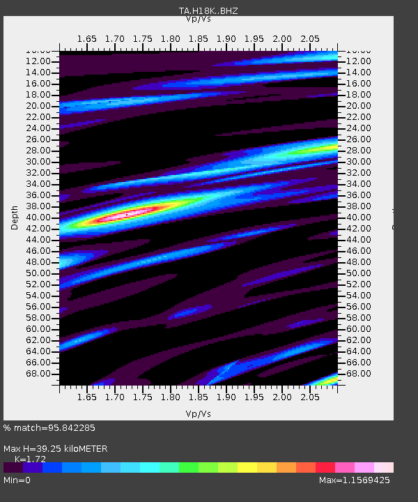
| Estimated Moho Depth: |
39.25 km |
| Estimated Crust Vp/Vs: |
1.72 |
| Assumed Crust Vp: |
6.1 km/s |
| Estimated Crust Vs: |
3.547 km/s |
| Estimated Crust Poisson's Ratio: |
0.24 |
|
| Radial Match: |
95.842285 % |
| Radial Bump: |
400 |
| Transverse Match: |
89.70049 % |
| Transverse Bump: |
400 |
| SOD ConfigId: |
13570011 |
| Insert Time: |
2019-05-01 00:56:04.338 +0000 |
| GWidth: |
2.5 |
| Max Bumps: |
400 |
| Tol: |
0.001 |
|

Signal To Noise
| Channel | StoN | STA | LTA |
| TA:H18K: :BHZ:20180828T22:44:46.450012Z | 45.63268 | 3.3476324E-6 | 7.336042E-8 |
| TA:H18K: :BHN:20180828T22:44:46.450012Z | 8.751263 | 5.466539E-7 | 6.2465716E-8 |
| TA:H18K: :BHE:20180828T22:44:46.450012Z | 25.810465 | 1.5506954E-6 | 6.0080104E-8 |
| Arrivals |
| Ps | 4.8 SECOND |
| PpPs | 17 SECOND |
| PsPs/PpSs | 22 SECOND |


