You are here: Home > Network List > TA - USArray Transportable Network (new EarthScope stations) Stations List
> Station L16K Owhat River, AK, USA > Earthquake Result Viewer
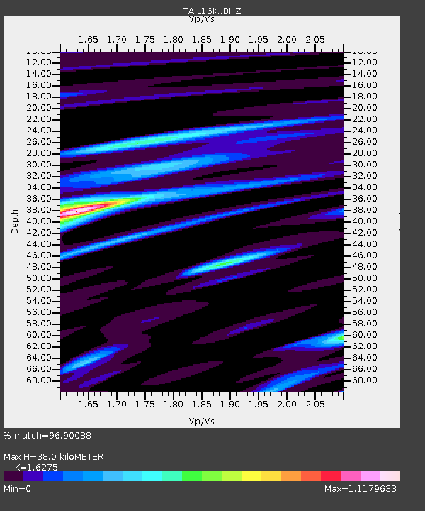
L16K Owhat River, AK, USA - Earthquake Result Viewer
| Earthquake location: |
Mariana Islands Region |
| Earthquake latitude/longitude: |
16.8/147.1 |
| Earthquake time(UTC): |
2018/08/28 (240) 22:35:14 GMT |
| Earthquake Depth: |
53 km |
| Earthquake Magnitude: |
6.6 Mi |
| Earthquake Catalog/Contributor: |
NEIC PDE/at |
|
| Network: |
TA USArray Transportable Network (new EarthScope stations) |
| Station: |
L16K Owhat River, AK, USA |
| Lat/Lon: |
61.71 N/159.47 W |
| Elevation: |
227 m |
|
| Distance: |
58.4 deg |
| Az: |
26.702 deg |
| Baz: |
244.617 deg |
| Ray Param: |
0.06276514 |
| Estimated Moho Depth: |
38.0 km |
| Estimated Crust Vp/Vs: |
1.63 |
| Assumed Crust Vp: |
6.276 km/s |
| Estimated Crust Vs: |
3.856 km/s |
| Estimated Crust Poisson's Ratio: |
0.20 |
|
| Radial Match: |
96.90088 % |
| Radial Bump: |
357 |
| Transverse Match: |
89.01972 % |
| Transverse Bump: |
400 |
| SOD ConfigId: |
13570011 |
| Insert Time: |
2019-05-01 00:56:34.353 +0000 |
| GWidth: |
2.5 |
| Max Bumps: |
400 |
| Tol: |
0.001 |
|

Signal To Noise
| Channel | StoN | STA | LTA |
| TA:L16K: :BHZ:20180828T22:44:33.125Z | 36.765194 | 3.1770046E-6 | 8.641338E-8 |
| TA:L16K: :BHN:20180828T22:44:33.125Z | 5.95182 | 6.947906E-7 | 1.1673582E-7 |
| TA:L16K: :BHE:20180828T22:44:33.125Z | 17.636137 | 1.7536638E-6 | 9.9435816E-8 |
| Arrivals |
| Ps | 4.0 SECOND |
| PpPs | 15 SECOND |
| PsPs/PpSs | 19 SECOND |


