You are here: Home > Network List > TA - USArray Transportable Network (new EarthScope stations) Stations List
> Station N14K Kuskokwak Creek, AK, USA > Earthquake Result Viewer
N14K Kuskokwak Creek, AK, USA - Earthquake Result Viewer
| Earthquake location: |
Mariana Islands Region |
| Earthquake latitude/longitude: |
16.8/147.1 |
| Earthquake time(UTC): |
2018/08/28 (240) 22:35:14 GMT |
| Earthquake Depth: |
53 km |
| Earthquake Magnitude: |
6.6 Mi |
| Earthquake Catalog/Contributor: |
NEIC PDE/at |
|
| Network: |
TA USArray Transportable Network (new EarthScope stations) |
| Station: |
N14K Kuskokwak Creek, AK, USA |
| Lat/Lon: |
59.92 N/161.69 W |
| Elevation: |
21 m |
|
| Distance: |
56.6 deg |
| Az: |
28.05 deg |
| Baz: |
243.415 deg |
| Ray Param: |
0.06390174 |
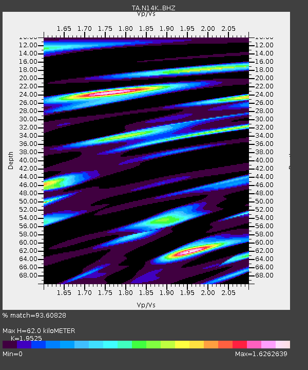
| Estimated Moho Depth: |
62.0 km |
| Estimated Crust Vp/Vs: |
1.95 |
| Assumed Crust Vp: |
6.24 km/s |
| Estimated Crust Vs: |
3.196 km/s |
| Estimated Crust Poisson's Ratio: |
0.32 |
|
| Radial Match: |
93.60828 % |
| Radial Bump: |
400 |
| Transverse Match: |
90.708336 % |
| Transverse Bump: |
400 |
| SOD ConfigId: |
13570011 |
| Insert Time: |
2019-05-01 00:56:55.288 +0000 |
| GWidth: |
2.5 |
| Max Bumps: |
400 |
| Tol: |
0.001 |
|

Signal To Noise
| Channel | StoN | STA | LTA |
| TA:N14K: :BHZ:20180828T22:44:20.825012Z | 30.320068 | 4.2839074E-6 | 1.412895E-7 |
| TA:N14K: :BHN:20180828T22:44:20.825012Z | 7.9210706 | 2.1153894E-6 | 2.6705854E-7 |
| TA:N14K: :BHE:20180828T22:44:20.825012Z | 8.828482 | 2.4607643E-6 | 2.787302E-7 |
| Arrivals |
| Ps | 9.9 SECOND |
| PpPs | 28 SECOND |
| PsPs/PpSs | 38 SECOND |


