You are here: Home > Network List > TA - USArray Transportable Network (new EarthScope stations) Stations List
> Station O14K Tigyukauivet Mountain, AK, USA > Earthquake Result Viewer
O14K Tigyukauivet Mountain, AK, USA - Earthquake Result Viewer
| Earthquake location: |
Mariana Islands Region |
| Earthquake latitude/longitude: |
16.8/147.1 |
| Earthquake time(UTC): |
2018/08/28 (240) 22:35:14 GMT |
| Earthquake Depth: |
53 km |
| Earthquake Magnitude: |
6.6 Mi |
| Earthquake Catalog/Contributor: |
NEIC PDE/at |
|
| Network: |
TA USArray Transportable Network (new EarthScope stations) |
| Station: |
O14K Tigyukauivet Mountain, AK, USA |
| Lat/Lon: |
59.25 N/161.26 W |
| Elevation: |
129 m |
|
| Distance: |
56.5 deg |
| Az: |
28.887 deg |
| Baz: |
244.239 deg |
| Ray Param: |
0.06397009 |
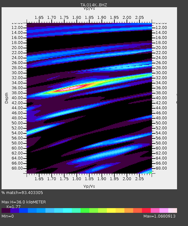
| Estimated Moho Depth: |
36.0 km |
| Estimated Crust Vp/Vs: |
1.77 |
| Assumed Crust Vp: |
6.24 km/s |
| Estimated Crust Vs: |
3.525 km/s |
| Estimated Crust Poisson's Ratio: |
0.27 |
|
| Radial Match: |
93.403305 % |
| Radial Bump: |
400 |
| Transverse Match: |
90.84391 % |
| Transverse Bump: |
400 |
| SOD ConfigId: |
13570011 |
| Insert Time: |
2019-05-01 00:57:04.851 +0000 |
| GWidth: |
2.5 |
| Max Bumps: |
400 |
| Tol: |
0.001 |
|

Signal To Noise
| Channel | StoN | STA | LTA |
| TA:O14K: :BHZ:20180828T22:44:20.125Z | 22.392813 | 3.1479588E-6 | 1.4057899E-7 |
| TA:O14K: :BHN:20180828T22:44:20.125Z | 6.7012954 | 7.0214725E-7 | 1.0477783E-7 |
| TA:O14K: :BHE:20180828T22:44:20.125Z | 18.413538 | 1.3634657E-6 | 7.4046916E-8 |
| Arrivals |
| Ps | 4.7 SECOND |
| PpPs | 15 SECOND |
| PsPs/PpSs | 20 SECOND |


