You are here: Home > Network List > CI - Caltech Regional Seismic Network Stations List
> Station PDM Parker Dam, Lake Havasu City, AZ, USA > Earthquake Result Viewer
PDM Parker Dam, Lake Havasu City, AZ, USA - Earthquake Result Viewer
| Earthquake location: |
Santiago Del Estero Prov., Arg. |
| Earthquake latitude/longitude: |
-28.6/-65.8 |
| Earthquake time(UTC): |
2004/09/07 (251) 11:53:06 GMT |
| Earthquake Depth: |
22 km |
| Earthquake Magnitude: |
6.1 MB, 6.1 MS, 6.4 MW, 6.2 MW |
| Earthquake Catalog/Contributor: |
WHDF/NEIC |
|
| Network: |
CI Caltech Regional Seismic Network |
| Station: |
PDM Parker Dam, Lake Havasu City, AZ, USA |
| Lat/Lon: |
34.30 N/114.14 W |
| Elevation: |
144 m |
|
| Distance: |
77.4 deg |
| Az: |
320.71 deg |
| Baz: |
137.715 deg |
| Ray Param: |
0.050296195 |
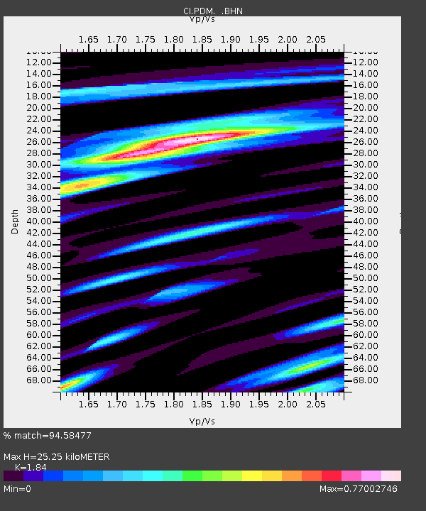
| Estimated Moho Depth: |
25.25 km |
| Estimated Crust Vp/Vs: |
1.84 |
| Assumed Crust Vp: |
6.276 km/s |
| Estimated Crust Vs: |
3.411 km/s |
| Estimated Crust Poisson's Ratio: |
0.29 |
|
| Radial Match: |
94.58477 % |
| Radial Bump: |
371 |
| Transverse Match: |
80.799706 % |
| Transverse Bump: |
400 |
| SOD ConfigId: |
2459 |
| Insert Time: |
2010-02-26 02:19:22.505 +0000 |
| GWidth: |
2.5 |
| Max Bumps: |
400 |
| Tol: |
0.001 |
|
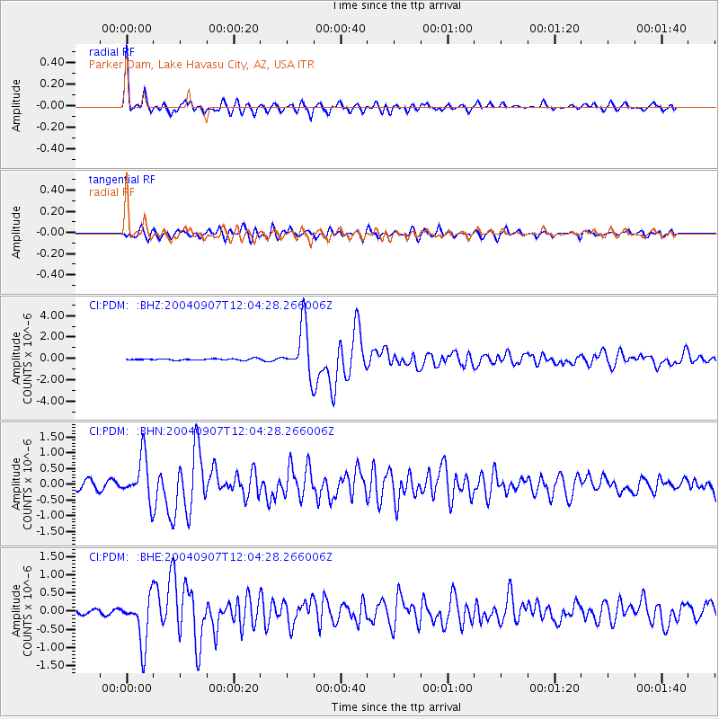
Signal To Noise
| Channel | StoN | STA | LTA |
| CI:PDM: :BHN:20040907T12:04:28.266006Z | 7.448229 | 7.0328355E-7 | 9.442292E-8 |
| CI:PDM: :BHE:20040907T12:04:28.266006Z | 9.215306 | 6.6723703E-7 | 7.24053E-8 |
| CI:PDM: :BHZ:20040907T12:04:28.266006Z | 35.108395 | 2.3578166E-6 | 6.7158204E-8 |
| Arrivals |
| Ps | 3.5 SECOND |
| PpPs | 11 SECOND |
| PsPs/PpSs | 15 SECOND |


