You are here: Home > Network List > TA - USArray Transportable Network (new EarthScope stations) Stations List
> Station P17K Kvichak River, AK, USA > Earthquake Result Viewer
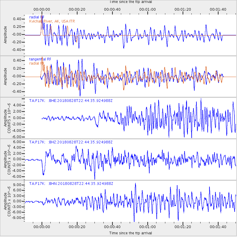
P17K Kvichak River, AK, USA - Earthquake Result Viewer
*The percent match for this event was below the threshold and hence no stack was calculated.
| Earthquake location: |
Mariana Islands Region |
| Earthquake latitude/longitude: |
16.8/147.1 |
| Earthquake time(UTC): |
2018/08/28 (240) 22:35:14 GMT |
| Earthquake Depth: |
53 km |
| Earthquake Magnitude: |
6.6 Mi |
| Earthquake Catalog/Contributor: |
NEIC PDE/at |
|
| Network: |
TA USArray Transportable Network (new EarthScope stations) |
| Station: |
P17K Kvichak River, AK, USA |
| Lat/Lon: |
59.20 N/156.44 W |
| Elevation: |
91 m |
|
| Distance: |
58.8 deg |
| Az: |
30.114 deg |
| Baz: |
249.034 deg |
| Ray Param: |
$rayparam |
*The percent match for this event was below the threshold and hence was not used in the summary stack. |
|
| Radial Match: |
75.23751 % |
| Radial Bump: |
400 |
| Transverse Match: |
61.25336 % |
| Transverse Bump: |
400 |
| SOD ConfigId: |
13570011 |
| Insert Time: |
2019-05-01 00:57:14.091 +0000 |
| GWidth: |
2.5 |
| Max Bumps: |
400 |
| Tol: |
0.001 |
|
Signal To Noise
| Channel | StoN | STA | LTA |
| TA:P17K: :BHZ:20180828T22:44:35.924988Z | 15.9819565 | 2.7174794E-6 | 1.7003421E-7 |
| TA:P17K: :BHN:20180828T22:44:35.924988Z | 2.3622837 | 8.5506366E-7 | 3.6196485E-7 |
| TA:P17K: :BHE:20180828T22:44:35.924988Z | 3.7780592 | 1.3291047E-6 | 3.5179562E-7 |
| Arrivals |
| Ps | |
| PpPs | |
| PsPs/PpSs | |


