You are here: Home > Network List > TD - TransAlta Monitoring Network Stations List
> Station TD010 Z > Earthquake Result Viewer
TD010 Z - Earthquake Result Viewer
| Earthquake location: |
Mariana Islands Region |
| Earthquake latitude/longitude: |
16.8/147.1 |
| Earthquake time(UTC): |
2018/08/28 (240) 22:35:14 GMT |
| Earthquake Depth: |
53 km |
| Earthquake Magnitude: |
6.6 Mi |
| Earthquake Catalog/Contributor: |
NEIC PDE/at |
|
| Network: |
TD TransAlta Monitoring Network |
| Station: |
TD010 Z |
| Lat/Lon: |
52.64 N/116.33 W |
| Elevation: |
1637 m |
|
| Distance: |
80.7 deg |
| Az: |
37.837 deg |
| Baz: |
285.389 deg |
| Ray Param: |
0.04798034 |
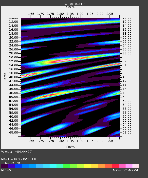
| Estimated Moho Depth: |
39.0 km |
| Estimated Crust Vp/Vs: |
1.63 |
| Assumed Crust Vp: |
6.142 km/s |
| Estimated Crust Vs: |
3.774 km/s |
| Estimated Crust Poisson's Ratio: |
0.20 |
|
| Radial Match: |
84.44417 % |
| Radial Bump: |
400 |
| Transverse Match: |
83.155846 % |
| Transverse Bump: |
400 |
| SOD ConfigId: |
13570011 |
| Insert Time: |
2019-05-01 00:57:49.065 +0000 |
| GWidth: |
2.5 |
| Max Bumps: |
400 |
| Tol: |
0.001 |
|

Signal To Noise
| Channel | StoN | STA | LTA |
| TD:TD010: :HHZ:20180828T22:46:50.549988Z | 21.93225 | 2.9035525E-6 | 1.3238736E-7 |
| TD:TD010: :HH1:20180828T22:46:50.549988Z | 4.65673 | 4.9818175E-7 | 1.0698103E-7 |
| TD:TD010: :HH2:20180828T22:46:50.549988Z | 8.111494 | 7.2644417E-7 | 8.955738E-8 |
| Arrivals |
| Ps | 4.1 SECOND |
| PpPs | 16 SECOND |
| PsPs/PpSs | 20 SECOND |


