You are here: Home > Network List > UM - University of Montana - Missoula Stations List
> Station GBMT Granite Butte > Earthquake Result Viewer
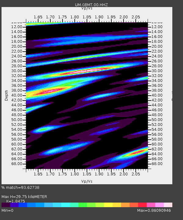
GBMT Granite Butte - Earthquake Result Viewer
| Earthquake location: |
Mariana Islands Region |
| Earthquake latitude/longitude: |
16.8/147.1 |
| Earthquake time(UTC): |
2018/08/28 (240) 22:35:14 GMT |
| Earthquake Depth: |
53 km |
| Earthquake Magnitude: |
6.6 Mi |
| Earthquake Catalog/Contributor: |
NEIC PDE/at |
|
| Network: |
UM University of Montana - Missoula |
| Station: |
GBMT Granite Butte |
| Lat/Lon: |
46.86 N/112.46 W |
| Elevation: |
2235 m |
|
| Distance: |
84.8 deg |
| Az: |
42.657 deg |
| Baz: |
288.949 deg |
| Ray Param: |
0.0450949 |
| Estimated Moho Depth: |
29.75 km |
| Estimated Crust Vp/Vs: |
1.85 |
| Assumed Crust Vp: |
6.353 km/s |
| Estimated Crust Vs: |
3.439 km/s |
| Estimated Crust Poisson's Ratio: |
0.29 |
|
| Radial Match: |
93.62738 % |
| Radial Bump: |
400 |
| Transverse Match: |
83.66981 % |
| Transverse Bump: |
400 |
| SOD ConfigId: |
13570011 |
| Insert Time: |
2019-05-01 00:58:11.238 +0000 |
| GWidth: |
2.5 |
| Max Bumps: |
400 |
| Tol: |
0.001 |
|

Signal To Noise
| Channel | StoN | STA | LTA |
| UM:GBMT:00:HHZ:20180828T22:47:11.809998Z | 32.514095 | 2.6730636E-6 | 8.221245E-8 |
| UM:GBMT:00:HHN:20180828T22:47:11.809998Z | 2.368416 | 3.6511818E-7 | 1.5416134E-7 |
| UM:GBMT:00:HHE:20180828T22:47:11.809998Z | 21.612215 | 1.0754704E-6 | 4.976216E-8 |
| Arrivals |
| Ps | 4.1 SECOND |
| PpPs | 13 SECOND |
| PsPs/PpSs | 17 SECOND |


