You are here: Home > Network List > UO - University of Oregon Regional Network Stations List
> Station WLOO Lebanon, OR, USA > Earthquake Result Viewer
WLOO Lebanon, OR, USA - Earthquake Result Viewer
| Earthquake location: |
Mariana Islands Region |
| Earthquake latitude/longitude: |
16.8/147.1 |
| Earthquake time(UTC): |
2018/08/28 (240) 22:35:14 GMT |
| Earthquake Depth: |
53 km |
| Earthquake Magnitude: |
6.6 Mi |
| Earthquake Catalog/Contributor: |
NEIC PDE/at |
|
| Network: |
UO University of Oregon Regional Network |
| Station: |
WLOO Lebanon, OR, USA |
| Lat/Lon: |
44.52 N/122.74 W |
| Elevation: |
284 m |
|
| Distance: |
78.5 deg |
| Az: |
46.876 deg |
| Baz: |
282.216 deg |
| Ray Param: |
0.04947838 |
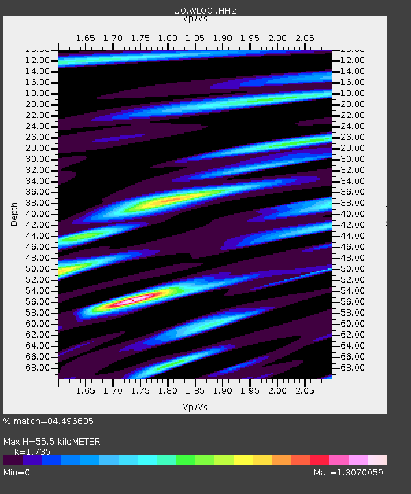
| Estimated Moho Depth: |
55.5 km |
| Estimated Crust Vp/Vs: |
1.74 |
| Assumed Crust Vp: |
6.566 km/s |
| Estimated Crust Vs: |
3.785 km/s |
| Estimated Crust Poisson's Ratio: |
0.25 |
|
| Radial Match: |
84.496635 % |
| Radial Bump: |
400 |
| Transverse Match: |
75.17718 % |
| Transverse Bump: |
400 |
| SOD ConfigId: |
13570011 |
| Insert Time: |
2019-05-01 00:58:24.267 +0000 |
| GWidth: |
2.5 |
| Max Bumps: |
400 |
| Tol: |
0.001 |
|

Signal To Noise
| Channel | StoN | STA | LTA |
| UO:WLOO: :HHZ:20180828T22:46:38.838013Z | 17.636461 | 4.844068E-6 | 2.7466214E-7 |
| UO:WLOO: :HHN:20180828T22:46:38.838013Z | 2.0028694 | 7.6315945E-7 | 3.8103306E-7 |
| UO:WLOO: :HHE:20180828T22:46:38.838013Z | 3.479762 | 1.1606124E-6 | 3.335321E-7 |
| Arrivals |
| Ps | 6.4 SECOND |
| PpPs | 22 SECOND |
| PsPs/PpSs | 29 SECOND |


