You are here: Home > Network List > GS - US Geological Survey Networks Stations List
> Station OK043 N2390 and E0400 Rds, Waynoka, OK, USA > Earthquake Result Viewer
OK043 N2390 and E0400 Rds, Waynoka, OK, USA - Earthquake Result Viewer
| Earthquake location: |
Near Coast Of Ecuador |
| Earthquake latitude/longitude: |
0.6/-79.6 |
| Earthquake time(UTC): |
2016/07/11 (193) 02:01:09 GMT |
| Earthquake Depth: |
14 km |
| Earthquake Magnitude: |
5.8 MWW, 5.7 MWB, 5.9 MWC |
| Earthquake Catalog/Contributor: |
NEIC PDE/NEIC COMCAT |
|
| Network: |
GS US Geological Survey Networks |
| Station: |
OK043 N2390 and E0400 Rds, Waynoka, OK, USA |
| Lat/Lon: |
36.43 N/98.75 W |
| Elevation: |
406 m |
|
| Distance: |
39.8 deg |
| Az: |
335.673 deg |
| Baz: |
149.284 deg |
| Ray Param: |
0.07474069 |
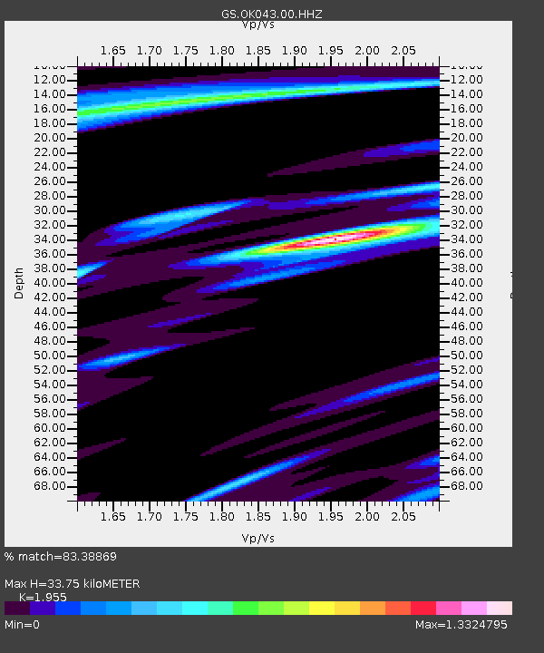
| Estimated Moho Depth: |
33.75 km |
| Estimated Crust Vp/Vs: |
1.96 |
| Assumed Crust Vp: |
6.426 km/s |
| Estimated Crust Vs: |
3.287 km/s |
| Estimated Crust Poisson's Ratio: |
0.32 |
|
| Radial Match: |
83.38869 % |
| Radial Bump: |
332 |
| Transverse Match: |
40.130188 % |
| Transverse Bump: |
400 |
| SOD ConfigId: |
1634031 |
| Insert Time: |
2016-07-25 02:06:49.340 +0000 |
| GWidth: |
2.5 |
| Max Bumps: |
400 |
| Tol: |
0.001 |
|

Signal To Noise
| Channel | StoN | STA | LTA |
| GS:OK043:00:HHZ:20160711T02:08:11.420011Z | 5.374874 | 5.716019E-7 | 1.0634703E-7 |
| GS:OK043:00:HH1:20160711T02:08:11.420011Z | 3.098478 | 3.890834E-7 | 1.2557243E-7 |
| GS:OK043:00:HH2:20160711T02:08:11.420011Z | 1.6400853 | 4.5929704E-7 | 2.800446E-7 |
| Arrivals |
| Ps | 5.3 SECOND |
| PpPs | 15 SECOND |
| PsPs/PpSs | 20 SECOND |


