You are here: Home > Network List > TA - USArray Transportable Network (new EarthScope stations) Stations List
> Station R16A Teasdale, UT, USA > Earthquake Result Viewer
R16A Teasdale, UT, USA - Earthquake Result Viewer
| Earthquake location: |
North Of Svalbard |
| Earthquake latitude/longitude: |
80.3/-1.9 |
| Earthquake time(UTC): |
2009/03/06 (065) 10:50:29 GMT |
| Earthquake Depth: |
9.0 km |
| Earthquake Magnitude: |
6.6 MB, 6.5 MS, 6.5 MW, 6.4 MW |
| Earthquake Catalog/Contributor: |
WHDF/NEIC |
|
| Network: |
TA USArray Transportable Network (new EarthScope stations) |
| Station: |
R16A Teasdale, UT, USA |
| Lat/Lon: |
38.28 N/111.48 W |
| Elevation: |
2202 m |
|
| Distance: |
55.7 deg |
| Az: |
296.213 deg |
| Baz: |
11.12 deg |
| Ray Param: |
0.064618334 |
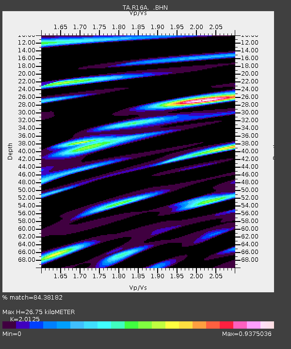
| Estimated Moho Depth: |
26.75 km |
| Estimated Crust Vp/Vs: |
2.01 |
| Assumed Crust Vp: |
6.207 km/s |
| Estimated Crust Vs: |
3.084 km/s |
| Estimated Crust Poisson's Ratio: |
0.34 |
|
| Radial Match: |
84.38182 % |
| Radial Bump: |
400 |
| Transverse Match: |
73.52071 % |
| Transverse Bump: |
400 |
| SOD ConfigId: |
2658 |
| Insert Time: |
2010-03-06 14:57:26.083 +0000 |
| GWidth: |
2.5 |
| Max Bumps: |
400 |
| Tol: |
0.001 |
|

Signal To Noise
| Channel | StoN | STA | LTA |
| TA:R16A: :BHN:20090306T10:59:35.050015Z | 14.547552 | 3.3856281E-6 | 2.3272838E-7 |
| TA:R16A: :BHE:20090306T10:59:35.050015Z | 8.993455 | 1.7179743E-6 | 1.9102495E-7 |
| TA:R16A: :BHZ:20090306T10:59:35.050015Z | 3.2622254 | 6.2344037E-7 | 1.9110891E-7 |
| Arrivals |
| Ps | 4.6 SECOND |
| PpPs | 12 SECOND |
| PsPs/PpSs | 17 SECOND |


