You are here: Home > Network List > YX16 - Raton Basin UNM Broadband Network Stations List
> Station UNM2 SE Corner of NM Stations > Earthquake Result Viewer
UNM2 SE Corner of NM Stations - Earthquake Result Viewer
| Earthquake location: |
Mariana Islands Region |
| Earthquake latitude/longitude: |
16.8/147.1 |
| Earthquake time(UTC): |
2018/08/28 (240) 22:35:14 GMT |
| Earthquake Depth: |
53 km |
| Earthquake Magnitude: |
6.6 Mi |
| Earthquake Catalog/Contributor: |
NEIC PDE/at |
|
| Network: |
YX Raton Basin UNM Broadband Network |
| Station: |
UNM2 SE Corner of NM Stations |
| Lat/Lon: |
36.80 N/104.86 W |
| Elevation: |
2166 m |
|
| Distance: |
93.8 deg |
| Az: |
49.898 deg |
| Baz: |
294.102 deg |
| Ray Param: |
0.04115835 |
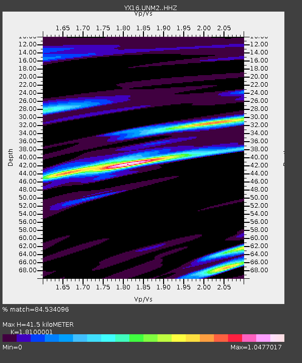
| Estimated Moho Depth: |
41.5 km |
| Estimated Crust Vp/Vs: |
1.81 |
| Assumed Crust Vp: |
6.316 km/s |
| Estimated Crust Vs: |
3.489 km/s |
| Estimated Crust Poisson's Ratio: |
0.28 |
|
| Radial Match: |
84.534096 % |
| Radial Bump: |
400 |
| Transverse Match: |
81.7539 % |
| Transverse Bump: |
400 |
| SOD ConfigId: |
13570011 |
| Insert Time: |
2019-05-01 00:59:42.386 +0000 |
| GWidth: |
2.5 |
| Max Bumps: |
400 |
| Tol: |
0.001 |
|

Signal To Noise
| Channel | StoN | STA | LTA |
| YX:UNM2: :HHZ:20180828T22:47:54.179993Z | 17.497864 | 9.503788E-7 | 5.4313993E-8 |
| YX:UNM2: :HHN:20180828T22:47:54.179993Z | 2.7292438 | 1.6801462E-7 | 6.1560876E-8 |
| YX:UNM2: :HHE:20180828T22:47:54.179993Z | 5.139385 | 2.5459468E-7 | 4.9537967E-8 |
| Arrivals |
| Ps | 5.4 SECOND |
| PpPs | 18 SECOND |
| PsPs/PpSs | 24 SECOND |


