You are here: Home > Network List > YX16 - Raton Basin UNM Broadband Network Stations List
> Station UNM4 NW Corner of NM Stations > Earthquake Result Viewer
UNM4 NW Corner of NM Stations - Earthquake Result Viewer
| Earthquake location: |
Mariana Islands Region |
| Earthquake latitude/longitude: |
16.8/147.1 |
| Earthquake time(UTC): |
2018/08/28 (240) 22:35:14 GMT |
| Earthquake Depth: |
53 km |
| Earthquake Magnitude: |
6.6 Mi |
| Earthquake Catalog/Contributor: |
NEIC PDE/at |
|
| Network: |
YX Raton Basin UNM Broadband Network |
| Station: |
UNM4 NW Corner of NM Stations |
| Lat/Lon: |
36.99 N/105.06 W |
| Elevation: |
2784 m |
|
| Distance: |
93.6 deg |
| Az: |
49.787 deg |
| Baz: |
293.994 deg |
| Ray Param: |
0.041204285 |
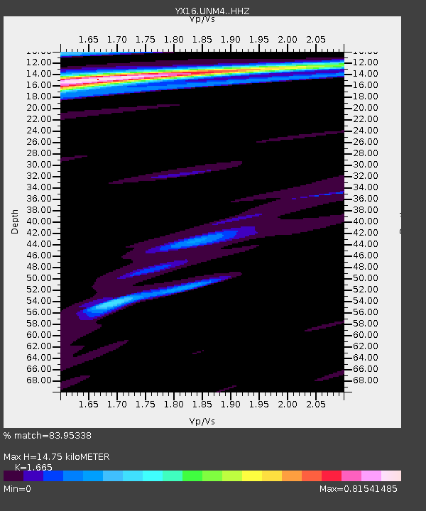
| Estimated Moho Depth: |
14.75 km |
| Estimated Crust Vp/Vs: |
1.66 |
| Assumed Crust Vp: |
6.316 km/s |
| Estimated Crust Vs: |
3.793 km/s |
| Estimated Crust Poisson's Ratio: |
0.22 |
|
| Radial Match: |
83.95338 % |
| Radial Bump: |
400 |
| Transverse Match: |
79.81089 % |
| Transverse Bump: |
400 |
| SOD ConfigId: |
13570011 |
| Insert Time: |
2019-05-01 00:59:46.638 +0000 |
| GWidth: |
2.5 |
| Max Bumps: |
400 |
| Tol: |
0.001 |
|

Signal To Noise
| Channel | StoN | STA | LTA |
| YX:UNM4: :HHZ:20180828T22:47:53.179993Z | 16.993658 | 1.0974011E-6 | 6.45771E-8 |
| YX:UNM4: :HHN:20180828T22:47:53.179993Z | 2.2089095 | 1.0284254E-7 | 4.655806E-8 |
| YX:UNM4: :HHE:20180828T22:47:53.179993Z | 3.3889298 | 2.5711776E-7 | 7.58699E-8 |
| Arrivals |
| Ps | 1.6 SECOND |
| PpPs | 6.1 SECOND |
| PsPs/PpSs | 7.7 SECOND |


