You are here: Home > Network List > TA - USArray Transportable Network (new EarthScope stations) Stations List
> Station R16A Teasdale, UT, USA > Earthquake Result Viewer
R16A Teasdale, UT, USA - Earthquake Result Viewer
| Earthquake location: |
Galapagos Islands, Ecuador |
| Earthquake latitude/longitude: |
-0.6/-91.3 |
| Earthquake time(UTC): |
2007/08/29 (241) 22:10:10 GMT |
| Earthquake Depth: |
23 km |
| Earthquake Magnitude: |
5.6 MB, 4.8 MS, 5.4 MW |
| Earthquake Catalog/Contributor: |
WHDF/NEIC |
|
| Network: |
TA USArray Transportable Network (new EarthScope stations) |
| Station: |
R16A Teasdale, UT, USA |
| Lat/Lon: |
38.28 N/111.48 W |
| Elevation: |
2202 m |
|
| Distance: |
42.9 deg |
| Az: |
336.528 deg |
| Baz: |
149.596 deg |
| Ray Param: |
0.072874695 |
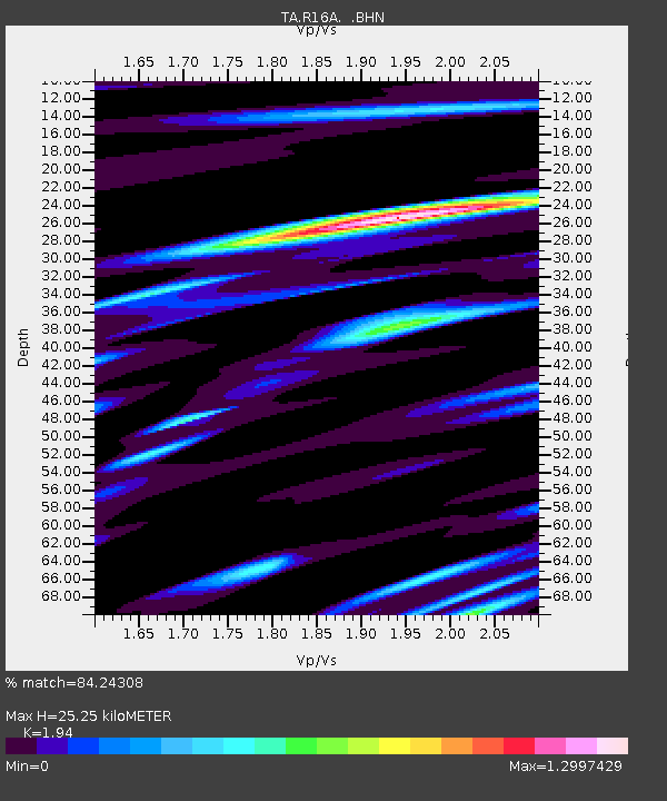
| Estimated Moho Depth: |
25.25 km |
| Estimated Crust Vp/Vs: |
1.94 |
| Assumed Crust Vp: |
6.207 km/s |
| Estimated Crust Vs: |
3.199 km/s |
| Estimated Crust Poisson's Ratio: |
0.32 |
|
| Radial Match: |
84.24308 % |
| Radial Bump: |
400 |
| Transverse Match: |
60.27396 % |
| Transverse Bump: |
400 |
| SOD ConfigId: |
2564 |
| Insert Time: |
2010-03-06 14:57:47.992 +0000 |
| GWidth: |
2.5 |
| Max Bumps: |
400 |
| Tol: |
0.001 |
|

Signal To Noise
| Channel | StoN | STA | LTA |
| TA:R16A: :BHN:20070829T22:17:36.199012Z | 3.3100545 | 1.7044124E-7 | 5.1491977E-8 |
| TA:R16A: :BHE:20070829T22:17:36.199012Z | 2.4543216 | 1.4303406E-7 | 5.8278452E-8 |
| TA:R16A: :BHZ:20070829T22:17:36.199012Z | 3.840222 | 2.589845E-7 | 6.7439984E-8 |
| Arrivals |
| Ps | 4.0 SECOND |
| PpPs | 11 SECOND |
| PsPs/PpSs | 15 SECOND |


