You are here: Home > Network List > 2H - Interim Broadband Monitoring of the Mount Erebus Volcano Stations List
> Station CONZ Mt Erebus site CONZ > Earthquake Result Viewer
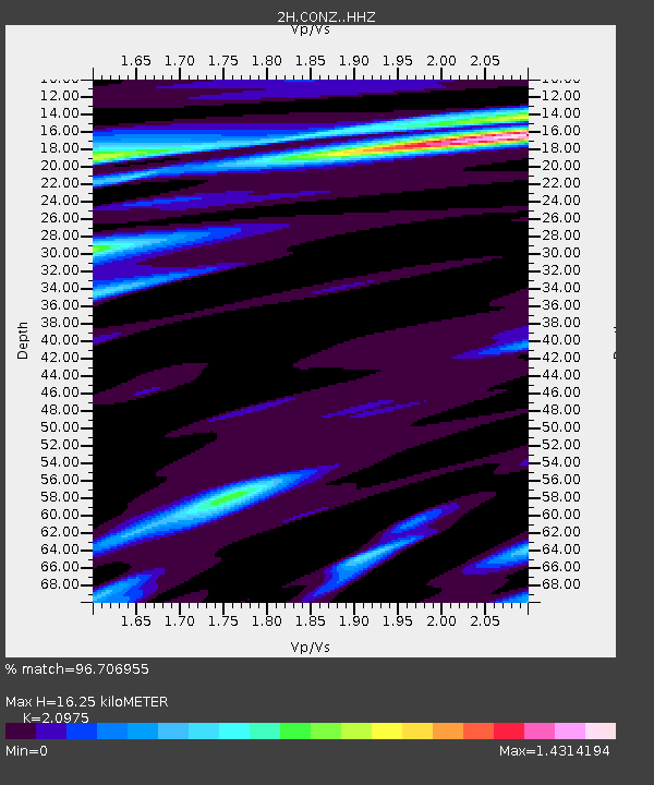
CONZ Mt Erebus site CONZ - Earthquake Result Viewer
| Earthquake location: |
Southeast Of Loyalty Islands |
| Earthquake latitude/longitude: |
-22.2/170.0 |
| Earthquake time(UTC): |
2018/08/29 (241) 03:51:55 GMT |
| Earthquake Depth: |
10 km |
| Earthquake Magnitude: |
7.0 Mi |
| Earthquake Catalog/Contributor: |
NEIC PDE/pt |
|
| Network: |
2H Interim Broadband Monitoring of the Mount Erebus Volcano |
| Station: |
CONZ Mt Erebus site CONZ |
| Lat/Lon: |
77.53 S/167.08 E |
| Elevation: |
3433 m |
|
| Distance: |
55.4 deg |
| Az: |
180.764 deg |
| Baz: |
3.259 deg |
| Ray Param: |
0.0648084 |
| Estimated Moho Depth: |
16.25 km |
| Estimated Crust Vp/Vs: |
2.10 |
| Assumed Crust Vp: |
6.183 km/s |
| Estimated Crust Vs: |
2.948 km/s |
| Estimated Crust Poisson's Ratio: |
0.35 |
|
| Radial Match: |
96.706955 % |
| Radial Bump: |
400 |
| Transverse Match: |
90.9316 % |
| Transverse Bump: |
400 |
| SOD ConfigId: |
13570011 |
| Insert Time: |
2019-05-01 01:06:57.302 +0000 |
| GWidth: |
2.5 |
| Max Bumps: |
400 |
| Tol: |
0.001 |
|

Signal To Noise
| Channel | StoN | STA | LTA |
| 2H:CONZ: :HHZ:20180829T04:00:58.903992Z | 3.415105 | 6.3955144E-7 | 1.8727138E-7 |
| 2H:CONZ: :HH1:20180829T04:00:58.903992Z | 1.1297383 | 2.7429218E-7 | 2.4279265E-7 |
| 2H:CONZ: :HH2:20180829T04:00:58.903992Z | 0.6224137 | 2.674806E-7 | 4.297473E-7 |
| Arrivals |
| Ps | 3.0 SECOND |
| PpPs | 7.8 SECOND |
| PsPs/PpSs | 11 SECOND |


