You are here: Home > Network List > 2H - Interim Broadband Monitoring of the Mount Erebus Volcano Stations List
> Station NAUS Mt Erebus site NAUS > Earthquake Result Viewer
NAUS Mt Erebus site NAUS - Earthquake Result Viewer
| Earthquake location: |
Southeast Of Loyalty Islands |
| Earthquake latitude/longitude: |
-22.2/170.0 |
| Earthquake time(UTC): |
2018/08/29 (241) 03:51:55 GMT |
| Earthquake Depth: |
10 km |
| Earthquake Magnitude: |
7.0 Mi |
| Earthquake Catalog/Contributor: |
NEIC PDE/pt |
|
| Network: |
2H Interim Broadband Monitoring of the Mount Erebus Volcano |
| Station: |
NAUS Mt Erebus site NAUS |
| Lat/Lon: |
77.52 S/167.15 E |
| Elevation: |
3590 m |
|
| Distance: |
55.4 deg |
| Az: |
180.746 deg |
| Baz: |
3.183 deg |
| Ray Param: |
0.06481614 |
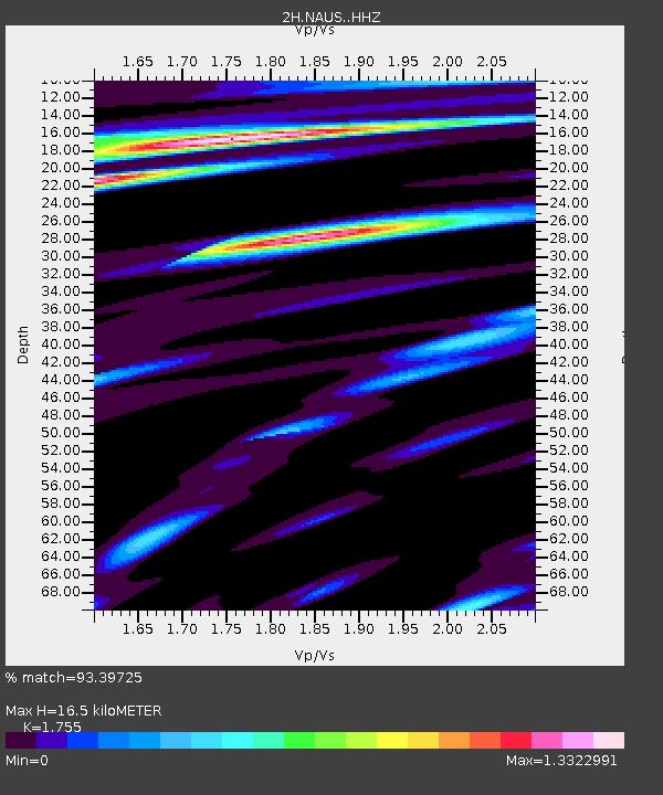
| Estimated Moho Depth: |
16.5 km |
| Estimated Crust Vp/Vs: |
1.75 |
| Assumed Crust Vp: |
6.183 km/s |
| Estimated Crust Vs: |
3.523 km/s |
| Estimated Crust Poisson's Ratio: |
0.26 |
|
| Radial Match: |
93.39725 % |
| Radial Bump: |
400 |
| Transverse Match: |
80.50104 % |
| Transverse Bump: |
400 |
| SOD ConfigId: |
13570011 |
| Insert Time: |
2019-05-01 01:06:58.409 +0000 |
| GWidth: |
2.5 |
| Max Bumps: |
400 |
| Tol: |
0.001 |
|

Signal To Noise
| Channel | StoN | STA | LTA |
| 2H:NAUS: :HHZ:20180829T04:00:58.81897Z | 4.3159757 | 6.2466967E-7 | 1.4473427E-7 |
| 2H:NAUS: :HH1:20180829T04:00:58.81897Z | 1.8829026 | 4.766404E-7 | 2.5314128E-7 |
| 2H:NAUS: :HH2:20180829T04:00:58.81897Z | 0.23297606 | 9.592604E-8 | 4.1174206E-7 |
| Arrivals |
| Ps | 2.1 SECOND |
| PpPs | 7.0 SECOND |
| PsPs/PpSs | 9.1 SECOND |


