You are here: Home > Network List > AE - Arizona Broadband Seismic Network Stations List
> Station DUN6 Lazy B Ranch > Earthquake Result Viewer
DUN6 Lazy B Ranch - Earthquake Result Viewer
| Earthquake location: |
Southeast Of Loyalty Islands |
| Earthquake latitude/longitude: |
-22.2/170.0 |
| Earthquake time(UTC): |
2018/08/29 (241) 03:51:55 GMT |
| Earthquake Depth: |
10 km |
| Earthquake Magnitude: |
7.0 Mi |
| Earthquake Catalog/Contributor: |
NEIC PDE/pt |
|
| Network: |
AE Arizona Broadband Seismic Network |
| Station: |
DUN6 Lazy B Ranch |
| Lat/Lon: |
32.55 N/109.09 W |
| Elevation: |
1259 m |
|
| Distance: |
94.5 deg |
| Az: |
56.772 deg |
| Baz: |
246.639 deg |
| Ray Param: |
0.04103872 |
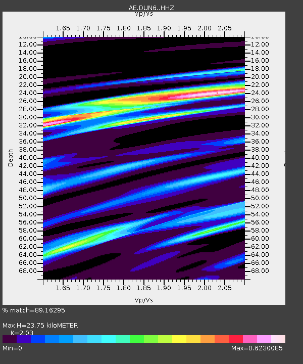
| Estimated Moho Depth: |
23.75 km |
| Estimated Crust Vp/Vs: |
2.03 |
| Assumed Crust Vp: |
6.276 km/s |
| Estimated Crust Vs: |
3.092 km/s |
| Estimated Crust Poisson's Ratio: |
0.34 |
|
| Radial Match: |
89.16295 % |
| Radial Bump: |
400 |
| Transverse Match: |
54.75887 % |
| Transverse Bump: |
400 |
| SOD ConfigId: |
13570011 |
| Insert Time: |
2019-05-01 01:07:04.365 +0000 |
| GWidth: |
2.5 |
| Max Bumps: |
400 |
| Tol: |
0.001 |
|

Signal To Noise
| Channel | StoN | STA | LTA |
| AE:DUN6: :HHZ:20180829T04:04:42.479004Z | 10.84002 | 2.2505883E-6 | 2.0761846E-7 |
| AE:DUN6: :HHN:20180829T04:04:42.479004Z | 2.8807638 | 5.593786E-7 | 1.9417716E-7 |
| AE:DUN6: :HHE:20180829T04:04:42.479004Z | 3.6801274 | 7.733985E-7 | 2.1015535E-7 |
| Arrivals |
| Ps | 4.0 SECOND |
| PpPs | 11 SECOND |
| PsPs/PpSs | 15 SECOND |


