You are here: Home > Network List > AK - Alaska Regional Network Stations List
> Station CCB Clear Creek Butte > Earthquake Result Viewer
CCB Clear Creek Butte - Earthquake Result Viewer
| Earthquake location: |
Southeast Of Loyalty Islands |
| Earthquake latitude/longitude: |
-22.2/170.0 |
| Earthquake time(UTC): |
2018/08/29 (241) 03:51:55 GMT |
| Earthquake Depth: |
10 km |
| Earthquake Magnitude: |
7.0 Mi |
| Earthquake Catalog/Contributor: |
NEIC PDE/pt |
|
| Network: |
AK Alaska Regional Network |
| Station: |
CCB Clear Creek Butte |
| Lat/Lon: |
64.65 N/147.80 W |
| Elevation: |
248 m |
|
| Distance: |
92.5 deg |
| Az: |
16.834 deg |
| Baz: |
218.565 deg |
| Ray Param: |
0.04144896 |
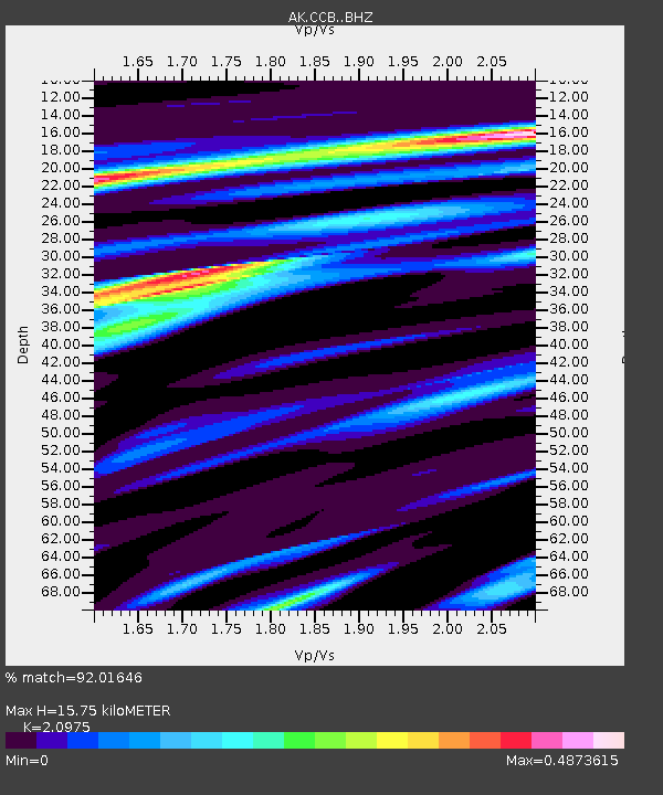
| Estimated Moho Depth: |
15.75 km |
| Estimated Crust Vp/Vs: |
2.10 |
| Assumed Crust Vp: |
6.566 km/s |
| Estimated Crust Vs: |
3.13 km/s |
| Estimated Crust Poisson's Ratio: |
0.35 |
|
| Radial Match: |
92.01646 % |
| Radial Bump: |
400 |
| Transverse Match: |
76.9463 % |
| Transverse Bump: |
400 |
| SOD ConfigId: |
13570011 |
| Insert Time: |
2019-05-01 01:07:18.609 +0000 |
| GWidth: |
2.5 |
| Max Bumps: |
400 |
| Tol: |
0.001 |
|

Signal To Noise
| Channel | StoN | STA | LTA |
| AK:CCB: :BHZ:20180829T04:04:33.388Z | 7.4254103 | 6.3197837E-7 | 8.511023E-8 |
| AK:CCB: :BHN:20180829T04:04:33.388Z | 3.2295327 | 1.770856E-7 | 5.4833198E-8 |
| AK:CCB: :BHE:20180829T04:04:33.388Z | 1.4450449 | 1.15042035E-7 | 7.96114E-8 |
| Arrivals |
| Ps | 2.7 SECOND |
| PpPs | 7.3 SECOND |
| PsPs/PpSs | 10.0 SECOND |


