You are here: Home > Network List > AK - Alaska Regional Network Stations List
> Station HDA Harding Lake, AK, USA > Earthquake Result Viewer
HDA Harding Lake, AK, USA - Earthquake Result Viewer
| Earthquake location: |
Southeast Of Loyalty Islands |
| Earthquake latitude/longitude: |
-22.2/170.0 |
| Earthquake time(UTC): |
2018/08/29 (241) 03:51:55 GMT |
| Earthquake Depth: |
10 km |
| Earthquake Magnitude: |
7.0 Mi |
| Earthquake Catalog/Contributor: |
NEIC PDE/pt |
|
| Network: |
AK Alaska Regional Network |
| Station: |
HDA Harding Lake, AK, USA |
| Lat/Lon: |
64.41 N/146.95 W |
| Elevation: |
437 m |
|
| Distance: |
92.5 deg |
| Az: |
17.272 deg |
| Baz: |
219.316 deg |
| Ray Param: |
0.041439608 |
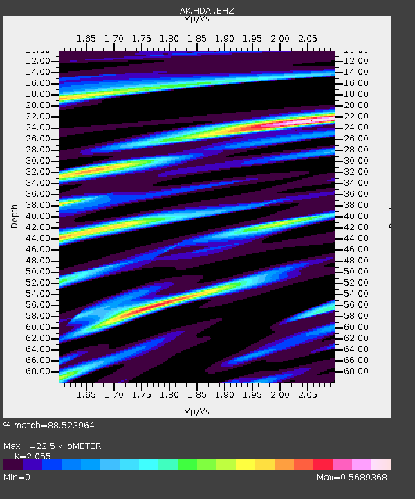
| Estimated Moho Depth: |
22.5 km |
| Estimated Crust Vp/Vs: |
2.06 |
| Assumed Crust Vp: |
6.566 km/s |
| Estimated Crust Vs: |
3.195 km/s |
| Estimated Crust Poisson's Ratio: |
0.34 |
|
| Radial Match: |
88.523964 % |
| Radial Bump: |
400 |
| Transverse Match: |
80.48459 % |
| Transverse Bump: |
400 |
| SOD ConfigId: |
13570011 |
| Insert Time: |
2019-05-01 01:07:37.270 +0000 |
| GWidth: |
2.5 |
| Max Bumps: |
400 |
| Tol: |
0.001 |
|

Signal To Noise
| Channel | StoN | STA | LTA |
| AK:HDA: :BHZ:20180829T04:04:33.599976Z | 9.8083315 | 8.195776E-7 | 8.355933E-8 |
| AK:HDA: :BHN:20180829T04:04:33.599976Z | 4.078914 | 2.97507E-7 | 7.2937794E-8 |
| AK:HDA: :BHE:20180829T04:04:33.599976Z | 3.0024676 | 1.8962169E-7 | 6.3155284E-8 |
| Arrivals |
| Ps | 3.7 SECOND |
| PpPs | 10 SECOND |
| PsPs/PpSs | 14 SECOND |


